Saqqez geodata
Saqqez (Kordestān) is a populated place; located in Iran in Asia/Tehran (GMT+3.5) time zone. With population of 151,237 people, there are 48 cities with bigger population in this country. Compared to other cities in Iran, 71.4% of cities are located further ↓South; 92.3% of cities are located further →East and 71.4% of cities have lower elevation than Saqqez. Note1


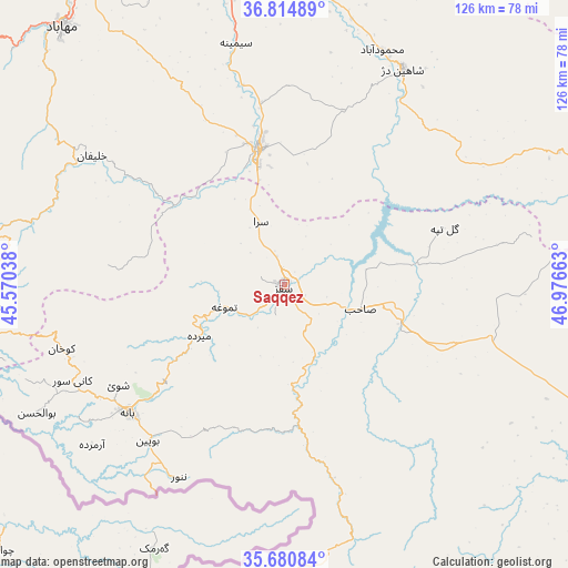
Saqqez GPS coordinates[2]
36° 14' 59.712" North, 46° 16' 24.6" East
| Map corner | latitude | longitude |
|---|---|---|
| Upper-left | 36.81489°, | 45.57038° |
| Center: | 36.24992°, | 46.2735° |
| Lower-right: | 35.68084°, | 46.97663° |
| Map W x H: | 126.1×126.1 km | = 78.4×78.4mi |
| max Lat: | 39.6482° ⇑28.6% North |
| Saqqez: | 36.24992° |
| min Lat: | ⇓71.4% South 25.2919° |
| min Long | Saqqez | max Long |
| 44.38416° | 46.2735° | 61.9965° |
| W 7.7%⇐ | ⇒92.3% E |
Elevation
Elevation of Saqqez is 1520 m = 4987 ft, and this is 471 m = 1545 ft above average elevation for this country.
| Max E: |
2564 m = 8412 ft | 28.6% |
| Saqqez | 1520 m 4987 ft | |
| Avg. | 1049 m = 3442 ft | |
Min E: |
-24 m = -79 ft | 71.4% |
See also: Saqqez elevation on elevation.city.
Geographical zone
Saqqez is located in North temperate zone (between Tropic of Cancer and the Arctic Circle). Distance of this Northern Tropic circle is 1424.7 km =885.3 mi to South.| Distance of | km | miles | from Saqqez |
|---|---|---|---|
| North Pole | 5976.4 | 3713.6 | to North |
| Arctic Circle | 3370.6 | 2094.4 | to North |
| Tropic Cancer | 1424.7 | 885.3 | to South |
| Equator | 4030.6 | 2504.5 | to South |


Nearby cities:
15 places around Saqqez: (largest is in red/bold)
• Bonāb
122.8 km =76.3 mi,  350°
350°
• Bāneh
44.8 km =27.8 mi,  231°
231°
• Būkān
30.7 km =19.1 mi, 349°
• Dīvāndarreh
77.1 km =47.9 mi,  118°
118°
• Mahābād
75.4 km =46.9 mi,  319°
319°
• Malekān
100.4 km =62.4 mi, 351°
• Marīvān
81.8 km =50.8 mi,  185°
185°
• Mīāndoāb
81 km =50.3 mi, 349°
• Naqadeh
111.3 km =69.2 mi,  314°
314°
• Piranshahr
113 km =70.2 mi,  296°
296°
• Sanandaj
122.8 km =76.3 mi,  147°
147°
• Sardasht
72.1 km =44.8 mi,  261°
261°
• Sarvābād
104.6 km =65 mi,  175°
175°
• Shāhīn Dezh
54.5 km =33.9 mi,  28°
28°
• Takāb
77.1 km =47.9 mi,  77°
77°
Sources, notices
• [Note1] Compared only with cities in Iran existing in our database
• [Src1] Map data: © OpenStreetMap contributors (CC-BY-SA)
• [Src2] Other city data from geonames.org with taken over terms of usage.
• [Src3] Geographical zone / Annual Mean Temperature by Robert A. Rohde @ Wikipedia
