Dīvāndarreh geodata
Dīvāndarreh (Kordestān) is a seat of a second-order administrative division; located in Iran in Asia/Tehran (GMT+3.5) time zone. In our database, there are 232 cities with bigger population. Compared to other cities in Iran, 67.8% of cities are located further ↓South; 88.7% of cities are located further →East and 88.9% of cities have lower elevation than Dīvāndarreh. Note1


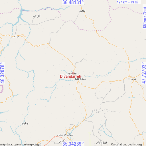
Dīvāndarreh GPS coordinates[2]
35° 54' 50.04" North, 47° 1' 26.04" East
| Map corner | latitude | longitude |
|---|---|---|
| Upper-left | 36.48131°, | 46.32078° |
| Center: | 35.9139°, | 47.0239° |
| Lower-right: | 35.34239°, | 47.72703° |
| Map W x H: | 126.6×126.6 km | = 78.7×78.7mi |
| max Lat: | 39.6482° ⇑32.2% North |
| Dīvāndarreh: | 35.9139° |
| min Lat: | ⇓67.8% South 25.2919° |
| min Long | Dīvāndarreh | max Long |
| 44.38416° | 47.0239° | 61.9965° |
| W 11.3%⇐ | ⇒88.7% E |
Elevation
Elevation of Dīvāndarreh is 1838 m = 6030 ft, and this is 789 m = 2589 ft above average elevation for this country.
| Max E: |
2564 m = 8412 ft | 11.1% |
| Dīvāndarreh | 1838 m 6030 ft | |
| Avg. | 1049 m = 3442 ft | |
Min E: |
-24 m = -79 ft | 88.9% |
See also: Iran elevation on elevation.city.
Geographical zone
Dīvāndarreh is located in North temperate zone (between Tropic of Cancer and the Arctic Circle). Distance of this Northern Tropic circle is 1387.3 km =862 mi to South.| Distance of | km | miles | from Dīvāndarreh |
|---|---|---|---|
| North Pole | 6013.8 | 3736.8 | to North |
| Arctic Circle | 3407.9 | 2117.6 | to North |
| Tropic Cancer | 1387.3 | 862 | to South |
| Equator | 3993.3 | 2481.3 | to South |


Nearby cities:
15 places around Dīvāndarreh: (largest is in red/bold)
• Bāneh
102.9 km =63.9 mi,  275°
275°
• Bījār
52.6 km =32.7 mi,  95°
95°
• Būkān
99.5 km =61.8 mi,  312°
312°
• Dehgolān
79.2 km =49.2 mi,  153°
153°
• Kāmyārān
124.6 km =77.4 mi,  183°
183°
• Marīvān
87.7 km =54.5 mi,  239°
239°
• Māhneshān
109.1 km =67.8 mi,  32°
32°
• Pāveh
114.1 km =70.9 mi,  211°
211°
• Qohūrd-e ‘Olyā
108.5 km =67.4 mi,  119°
119°
• Qorveh
109.1 km =67.8 mi,  139°
139°
• Sanandaj
66.6 km =41.4 mi, 181°
• Saqqez
77.1 km =47.9 mi,  298°
298°
• Sarvābād
89.4 km =55.6 mi,  221°
221°
• Shāhīn Dezh
94.4 km =58.7 mi,  334°
334°
• Takāb
54.7 km =34 mi,  8°
8°
Sources, notices
• [Note1] Compared only with cities in Iran existing in our database
• [Src1] Map data: © OpenStreetMap contributors (CC-BY-SA)
• [Src2] Other city data from geonames.org with taken over terms of usage.
• [Src3] Geographical zone / Annual Mean Temperature by Robert A. Rohde @ Wikipedia
