Bāneh geodata
Bāneh (Kordestān) is a seat of a second-order administrative division; located in Iran in Asia/Tehran (GMT+3.5) time zone. With population of 104,799 people, there are 64 cities with bigger population in this country. Compared to other cities in Iran, 68.5% of cities are located further ↓South; 95.9% of cities are located further →East and 71.9% of cities have lower elevation than Bāneh. Note1


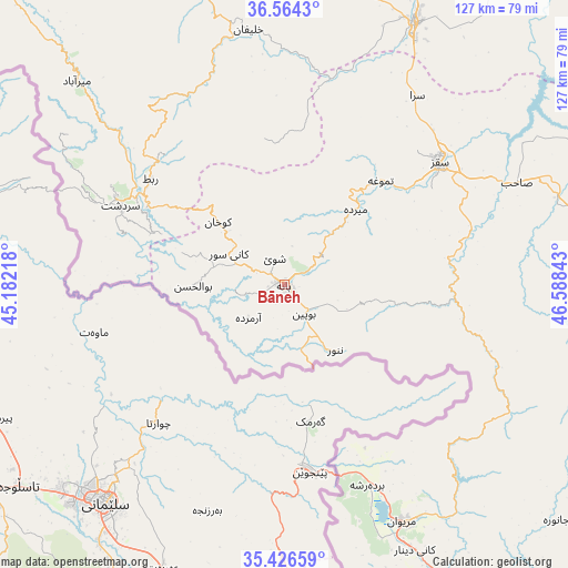
Bāneh GPS coordinates[2]
35° 59' 51" North, 45° 53' 7.08" East
| Map corner | latitude | longitude |
|---|---|---|
| Upper-left | 36.5643°, | 45.18218° |
| Center: | 35.9975°, | 45.8853° |
| Lower-right: | 35.42659°, | 46.58843° |
| Map W x H: | 126.5×126.5 km | = 78.6×78.6mi |
| max Lat: | 39.6482° ⇑31.5% North |
| Bāneh: | 35.9975° |
| min Lat: | ⇓68.5% South 25.2919° |
| min Long | Bāneh | max Long |
| 44.38416° | 45.8853° | 61.9965° |
| W 4.1%⇐ | ⇒95.9% E |
Elevation
Elevation of Bāneh is 1525 m = 5003 ft, and this is 476 m = 1562 ft above average elevation for this country.
| Max E: |
2564 m = 8412 ft | 28.1% |
| Bāneh | 1525 m 5003 ft | |
| Avg. | 1049 m = 3442 ft | |
Min E: |
-24 m = -79 ft | 71.9% |
See also: Bāneh elevation on elevation.city.
Geographical zone
Bāneh is located in North temperate zone (between Tropic of Cancer and the Arctic Circle). Distance of this Northern Tropic circle is 1396.6 km =867.8 mi to South.| Distance of | km | miles | from Bāneh |
|---|---|---|---|
| North Pole | 6004.5 | 3731 | to North |
| Arctic Circle | 3398.6 | 2111.8 | to North |
| Tropic Cancer | 1396.6 | 867.8 | to South |
| Equator | 4002.5 | 2487 | to South |


Nearby cities:
15 places around Bāneh: (largest is in red/bold)
• Būkān
65 km =40.4 mi,  26°
26°
• Dīvāndarreh
102.9 km =63.9 mi,  95°
95°
• Mahābād
86.4 km =53.7 mi,  350°
350°
• Malekān
128.8 km =80 mi,  8°
8°
• Marīvān
59.7 km =37.1 mi,  153°
153°
• Mīāndoāb
109.6 km =68.1 mi, 10°
• Naqadeh
115.4 km =71.7 mi,  337°
337°
• Piranshahr
102.8 km =63.9 mi,  319°
319°
• Pāveh
114.3 km =71 mi,  158°
158°
• Sanandaj
126 km =78.3 mi,  127°
127°
• Saqqez
44.8 km =27.8 mi,  51°
51°
• Sardasht
40.5 km =25.2 mi,  295°
295°
• Sarvābād
87.7 km =54.5 mi, 150°
• Shāhīn Dezh
97.3 km =60.5 mi,  38°
38°
• Takāb
119 km =73.9 mi,  67°
67°
Sources, notices
• [Note1] Compared only with cities in Iran existing in our database
• [Src1] Map data: © OpenStreetMap contributors (CC-BY-SA)
• [Src2] Other city data from geonames.org with taken over terms of usage.
• [Src3] Geographical zone / Annual Mean Temperature by Robert A. Rohde @ Wikipedia
