Sardasht geodata
Sardasht (West Azerbaijan) is a seat of a second-order administrative division; located in Iran in Asia/Tehran (GMT+3.5) time zone. In our database, there are 232 cities with bigger population. Compared to other cities in Iran, 69.8% of cities are located further ↓South; 97.5% of cities are located further →East and 71% of cities have lower elevation than Sardasht. Note1


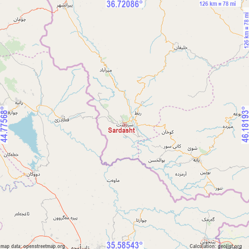
Sardasht GPS coordinates[2]
36° 9' 18.72" North, 45° 28' 43.68" East
| Map corner | latitude | longitude |
|---|---|---|
| Upper-left | 36.72086°, | 44.77568° |
| Center: | 36.1552°, | 45.4788° |
| Lower-right: | 35.58543°, | 46.18193° |
| Map W x H: | 126.2×126.2 km | = 78.4×78.4mi |
| max Lat: | 39.6482° ⇑30.2% North |
| Sardasht: | 36.1552° |
| min Lat: | ⇓69.8% South 25.2919° |
| min Long | Sardasht | max Long |
| 44.38416° | 45.4788° | 61.9965° |
| W 2.5%⇐ | ⇒97.5% E |
Elevation
Elevation of Sardasht is 1516 m = 4974 ft, and this is 467 m = 1532 ft above average elevation for this country.
| Max E: |
2564 m = 8412 ft | 29% |
| Sardasht | 1516 m 4974 ft | |
| Avg. | 1049 m = 3442 ft | |
Min E: |
-24 m = -79 ft | 71% |
See also: Iran elevation on elevation.city.
Geographical zone
Sardasht is located in North temperate zone (between Tropic of Cancer and the Arctic Circle). Distance of this Northern Tropic circle is 1414.2 km =878.7 mi to South.| Distance of | km | miles | from Sardasht |
|---|---|---|---|
| North Pole | 5987 | 3720.1 | to North |
| Arctic Circle | 3381.1 | 2100.9 | to North |
| Tropic Cancer | 1414.2 | 878.7 | to South |
| Equator | 4020.1 | 2498 | to South |


Nearby cities:
15 places around Sardasht: (largest is in red/bold)
• Bonāb
141.5 km =87.9 mi,  21°
21°
• Bāneh
40.5 km =25.2 mi,  115°
115°
• Būkān
77 km =47.8 mi,  58°
58°
• Dīvāndarreh
141.5 km =87.9 mi,  100°
100°
• Mahābād
71 km =44.1 mi, 17°
• Malekān
123.1 km =76.5 mi,  26°
26°
• Marīvān
95.1 km =59.1 mi,  138°
138°
• Mīāndoāb
106.4 km =66.1 mi, 31°
• Naqadeh
89.3 km =55.5 mi,  354°
354°
• Oshnavīyeh
104 km =64.6 mi,  340°
340°
• Piranshahr
67.8 km =42.1 mi,  333°
333°
• Pāveh
146.9 km =91.3 mi,  147°
147°
• Saqqez
72.1 km =44.8 mi,  81°
81°
• Sarvābād
123.3 km =76.6 mi, 139°
• Shāhīn Dezh
113.5 km =70.5 mi, 59°
Sources, notices
• [Note1] Compared only with cities in Iran existing in our database
• [Src1] Map data: © OpenStreetMap contributors (CC-BY-SA)
• [Src2] Other city data from geonames.org with taken over terms of usage.
• [Src3] Geographical zone / Annual Mean Temperature by Robert A. Rohde @ Wikipedia
