Piranshahr geodata
Piranshahr (West Azerbaijan) is a populated place; located in Iran in Asia/Tehran (GMT+3.5) time zone. With population of 61,973 people, there are 104 cities with bigger population in this country. Compared to other cities in Iran, 78% of cities are located further ↓South; 98% of cities are located further →East and 67.1% of cities have lower elevation than Piranshahr. Note1


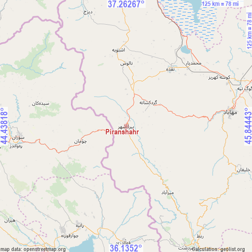
Piranshahr GPS coordinates[2]
36° 42' 3.6" North, 45° 8' 28.68" East
| Map corner | latitude | longitude |
|---|---|---|
| Upper-left | 37.26267°, | 44.43818° |
| Center: | 36.701°, | 45.1413° |
| Lower-right: | 36.1352°, | 45.84443° |
| Map W x H: | 125.4×125.4 km | = 77.9×77.9mi |
| max Lat: | 39.6482° ⇑22% North |
| Piranshahr: | 36.701° |
| min Lat: | ⇓78% South 25.2919° |
| min Long | Piranshahr | max Long |
| 44.38416° | 45.1413° | 61.9965° |
| W 2%⇐ | ⇒98% E |
Elevation
Elevation of Piranshahr is 1444 m = 4738 ft, and this is 395 m = 1296 ft above average elevation for this country.
| Max E: |
2564 m = 8412 ft | 32.9% |
| Piranshahr | 1444 m 4738 ft | |
| Avg. | 1049 m = 3442 ft | |
Min E: |
-24 m = -79 ft | 67.1% |
See also: Piranshahr elevation on elevation.city.
Geographical zone
Piranshahr is located in North temperate zone (between Tropic of Cancer and the Arctic Circle). Distance of this Northern Tropic circle is 1474.8 km =916.4 mi to South.| Distance of | km | miles | from Piranshahr |
|---|---|---|---|
| North Pole | 5926.3 | 3682.4 | to North |
| Arctic Circle | 3320.4 | 2063.2 | to North |
| Tropic Cancer | 1474.8 | 916.4 | to South |
| Equator | 4080.8 | 2535.7 | to South |


Nearby cities:
15 places around Piranshahr: (largest is in red/bold)
• Bonāb
107.9 km =67 mi,  48°
48°
• Bāneh
102.8 km =63.9 mi,  139°
139°
• Būkān
97.4 km =60.5 mi,  101°
101°
• Mahābād
52.2 km =32.4 mi,  82°
82°
• Malekān
98.6 km =61.3 mi,  60°
60°
• Marāgheh
124.1 km =77.1 mi, 51°
• Mīāndoāb
91.1 km =56.6 mi,  71°
71°
• Naqadeh
35.8 km =22.2 mi,  37°
37°
• Orūmīyeh
94.9 km =59 mi,  356°
356°
• Oshnavīyeh
37.9 km =23.5 mi,  354°
354°
• Saqqez
113 km =70.2 mi,  116°
116°
• Sardasht
67.8 km =42.1 mi,  153°
153°
• Shāhīn Dezh
127.1 km =79 mi,  91°
91°
• Āz̄arshahr
139 km =86.4 mi,  32°
32°
• ‘Ajab Shīr
109.2 km =67.9 mi, 37°
Sources, notices
• [Note1] Compared only with cities in Iran existing in our database
• [Src1] Map data: © OpenStreetMap contributors (CC-BY-SA)
• [Src2] Other city data from geonames.org with taken over terms of usage.
• [Src3] Geographical zone / Annual Mean Temperature by Robert A. Rohde @ Wikipedia
