Jongīyeh geodata
Jongīyeh (Khuzestan) is a populated place; located in Iran in Asia/Tehran (GMT+3.5) time zone. With population of 4,183 people, there are 215 cities with bigger population in this country. Compared to other cities in Iran, 74.8% of cities are located further ↑North; 74.8% of cities are located further →East and 89.6% of cities have higher elevation than Jongīyeh. Note1


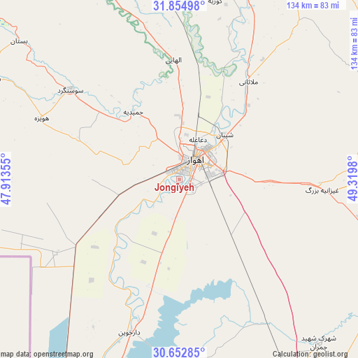
Jongīyeh GPS coordinates[2]
31° 15' 20.988" North, 48° 37' 0.012" East
| Map corner | latitude | longitude |
|---|---|---|
| Upper-left | 31.85498°, | 47.91355° |
| Center: | 31.25583°, | 48.61667° |
| Lower-right: | 30.65285°, | 49.3198° |
| Map W x H: | 133.7×133.7 km | = 83.1×83.1mi |
| max Lat: | 39.6482° ⇑74.8% North |
| Jongīyeh: | 31.25583° |
| min Lat: | ⇓25.2% South 25.2919° |
| min Long | Jongīyeh | max Long |
| 44.38416° | 48.61667° | 61.9965° |
| W 25.2%⇐ | ⇒74.8% E |
Elevation
Elevation of Jongīyeh is 16 m = 52 ft, and this is 1033 m = 3389 ft below average elevation for this country.
| Max E: |
2564 m = 8412 ft | 89.6% |
| Avg. | 1049 m = 3442 ft | |
| Jongīyeh | 16 m = 52 ft | |
Min E: |
-24 m = -79 ft | 10.4% |
See also: Iran elevation on elevation.city.
Geographical zone
Jongīyeh is located in North temperate zone (between Tropic of Cancer and the Arctic Circle). Distance of this Northern Tropic circle is 869.4 km =540.2 mi to South.| Distance of | km | miles | from Jongīyeh |
|---|---|---|---|
| North Pole | 6531.7 | 4058.6 | to North |
| Arctic Circle | 3925.9 | 2439.4 | to North |
| Tropic Cancer | 869.4 | 540.2 | to South |
| Equator | 3475.3 | 2159.5 | to South |


Nearby cities:
15 places around Jongīyeh: (largest is in red/bold)
• Abadan
106.2 km =66 mi,  196°
196°
• Ahvaz
9.5 km =5.9 mi,  42°
42°
• Bandar-e Emam Khomeyni
102.2 km =63.5 mi,  152°
152°
• Bandar-e Māhshahr
95 km =59 mi,  144°
144°
• Haftkel
89.2 km =55.4 mi,  76°
76°
• Hoveyzeh
56.4 km =35 mi,  293°
293°
• Khorramshahr
99.6 km =61.9 mi, 204°
• Masjed Soleymān
99.8 km =62 mi, 40°
• Mollās̄ānī
44.6 km =27.7 mi,  34°
34°
• Rāmhormoz
93.8 km =58.3 mi,  88°
88°
• Rāmshīr
85.5 km =53.1 mi,  118°
118°
• Shādegān
67.6 km =42 mi,  176°
176°
• Shūshtar
91 km =56.5 mi,  13°
13°
• Sūsangerd
53 km =32.9 mi,  310°
310°
• sedeyen-e Yek
22.5 km =14 mi,  58°
58°
Sources, notices
• [Note1] Compared only with cities in Iran existing in our database
• [Src1] Map data: © OpenStreetMap contributors (CC-BY-SA)
• [Src2] Other city data from geonames.org with taken over terms of usage.
• [Src3] Geographical zone / Annual Mean Temperature by Robert A. Rohde @ Wikipedia
