sedeyen-e Yek geodata
sedeyen-e Yek (Khuzestan) is a populated place; located in Iran in Asia/Tehran (GMT+3.5) time zone. With population of 1,082 people, there are 226 cities with bigger population in this country. Compared to other cities in Iran, 73.9% of cities are located further ↑North; 73.7% of cities are located further →East and 88.9% of cities have higher elevation than sedeyen-e Yek. Note1


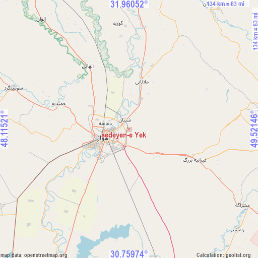
sedeyen-e Yek GPS coordinates[2]
31° 21' 43.38" North, 48° 49' 5.988" East
| Map corner | latitude | longitude |
|---|---|---|
| Upper-left | 31.96052°, | 48.11521° |
| Center: | 31.36205°, | 48.81833° |
| Lower-right: | 30.75974°, | 49.52146° |
| Map W x H: | 133.5×133.5 km | = 83×83mi |
| max Lat: | 39.6482° ⇑73.9% North |
| sedeyen-e Yek: | 31.36205° |
| min Lat: | ⇓26.1% South 25.2919° |
| min Long | sedeyen-e Yek | max Long |
| 44.38416° | 48.81833° | 61.9965° |
| W 26.3%⇐ | ⇒73.7% E |
Elevation
Elevation of sedeyen-e Yek is 21 m = 69 ft, and this is 1028 m = 3373 ft below average elevation for this country.
| Max E: |
2564 m = 8412 ft | 88.9% |
| Avg. | 1049 m = 3442 ft | |
| sedeyen-e Yek | 21 m = 69 ft | |
Min E: |
-24 m = -79 ft | 11.1% |
See also: Iran elevation on elevation.city.
Geographical zone
sedeyen-e Yek is located in North temperate zone (between Tropic of Cancer and the Arctic Circle). Distance of this Northern Tropic circle is 881.2 km =547.6 mi to South.| Distance of | km | miles | from sedeyen-e Yek |
|---|---|---|---|
| North Pole | 6519.9 | 4051.3 | to North |
| Arctic Circle | 3914 | 2432 | to North |
| Tropic Cancer | 881.2 | 547.6 | to South |
| Equator | 3487.1 | 2166.8 | to South |


Nearby cities:
15 places around sedeyen-e Yek: (largest is in red/bold)
• Ahvaz
13.6 km =8.5 mi,  249°
249°
• Bandar-e Emam Khomeyni
106.4 km =66.1 mi,  165°
165°
• Bandar-e Māhshahr
96.3 km =59.8 mi,  158°
158°
• Bāgh-e Malek
102.8 km =63.9 mi,  79°
79°
• Haftkel
68.1 km =42.3 mi, 82°
• Hoveyzeh
71.5 km =44.4 mi,  278°
278°
• Jongīyeh
22.5 km =14 mi,  238°
238°
• Masjed Soleymān
78.7 km =48.9 mi,  35°
35°
• Mollās̄ānī
25.6 km =15.9 mi,  14°
14°
• Rāmhormoz
75.1 km =46.7 mi,  96°
96°
• Rāmshīr
76.6 km =47.6 mi,  132°
132°
• Shādegān
80.6 km =50.1 mi,  190°
190°
• Shūsh
107.3 km =66.7 mi,  329°
329°
• Shūshtar
76.5 km =47.5 mi,  2°
2°
• Sūsangerd
63.7 km =39.6 mi,  290°
290°
Sources, notices
• [Note1] Compared only with cities in Iran existing in our database
• [Src1] Map data: © OpenStreetMap contributors (CC-BY-SA)
• [Src2] Other city data from geonames.org with taken over terms of usage.
• [Src3] Geographical zone / Annual Mean Temperature by Robert A. Rohde @ Wikipedia
