Haftkel geodata
Haftkel (Khuzestan) is a seat of a second-order administrative division; located in Iran in Asia/Tehran (GMT+3.5) time zone. In our database, there are 232 cities with bigger population. Compared to other cities in Iran, 73.2% of cities are located further ↑North; 66% of cities are located further →East and 77.3% of cities have higher elevation than Haftkel. Note1


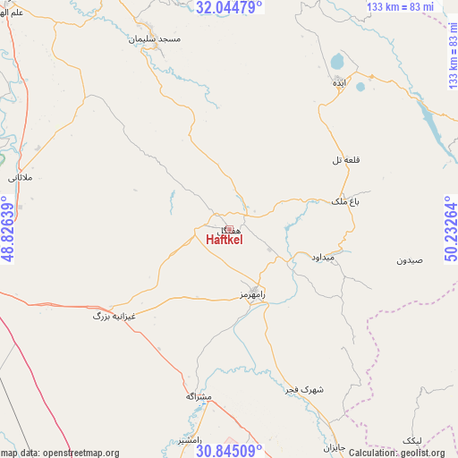
Haftkel GPS coordinates[2]
31° 26' 48.696" North, 49° 31' 46.236" East
| Map corner | latitude | longitude |
|---|---|---|
| Upper-left | 32.04479°, | 48.82639° |
| Center: | 31.44686°, | 49.52951° |
| Lower-right: | 30.84509°, | 50.23264° |
| Map W x H: | 133.4×133.4 km | = 82.9×82.9mi |
| max Lat: | 39.6482° ⇑73.2% North |
| Haftkel: | 31.44686° |
| min Lat: | ⇓26.8% South 25.2919° |
| min Long | Haftkel | max Long |
| 44.38416° | 49.52951° | 61.9965° |
| W 34%⇐ | ⇒66% E |
Elevation
Elevation of Haftkel is 298 m = 978 ft, and this is 751 m = 2464 ft below average elevation for this country.
| Max E: |
2564 m = 8412 ft | 77.3% |
| Avg. | 1049 m = 3442 ft | |
| Haftkel | 298 m = 978 ft | |
Min E: |
-24 m = -79 ft | 22.7% |
See also: Iran elevation on elevation.city.
Geographical zone
Haftkel is located in North temperate zone (between Tropic of Cancer and the Arctic Circle). Distance of this Northern Tropic circle is 890.6 km =553.4 mi to South.| Distance of | km | miles | from Haftkel |
|---|---|---|---|
| North Pole | 6510.5 | 4045.4 | to North |
| Arctic Circle | 3904.6 | 2426.2 | to North |
| Tropic Cancer | 890.6 | 553.4 | to South |
| Equator | 3496.6 | 2172.7 | to South |


Nearby cities:
15 places around Haftkel: (largest is in red/bold)
• Aghajari
87.8 km =54.6 mi,  160°
160°
• Ahvaz
81.5 km =50.6 mi,  259°
259°
• Bandar-e Māhshahr
104.2 km =64.7 mi,  198°
198°
• Bāgh-e Malek
34.8 km =21.6 mi,  75°
75°
• Dasht-e Lati
106.5 km =66.2 mi,  337°
337°
• Jongīyeh
89.2 km =55.4 mi, 256°
• Līkak
81.5 km =50.6 mi,  138°
138°
• Masjed Soleymān
58.5 km =36.4 mi, 338°
• Mollās̄ānī
62.9 km =39.1 mi,  284°
284°
• Omīdīyeh
77.8 km =48.3 mi,  167°
167°
• Qal‘eh-ye Khvājeh
84.8 km =52.7 mi,  354°
354°
• Rāmhormoz
19.8 km =12.3 mi, 159°
• Rāmshīr
62.6 km =38.9 mi,  190°
190°
• Shūshtar
93 km =57.8 mi,  316°
316°
• sedeyen-e Yek
68.1 km =42.3 mi, 262°
Sources, notices
• [Note1] Compared only with cities in Iran existing in our database
• [Src1] Map data: © OpenStreetMap contributors (CC-BY-SA)
• [Src2] Other city data from geonames.org with taken over terms of usage.
• [Src3] Geographical zone / Annual Mean Temperature by Robert A. Rohde @ Wikipedia
