Ahvaz geodata
Ahvaz (Khuzestan) is a seat of a first-order administrative division; located in Iran in Asia/Tehran (GMT+3.5) time zone. With population of 841,145 people, there are 7 cities with bigger population in this country. Compared to other cities in Iran, 74.1% of cities are located further ↑North; 74.4% of cities are located further →East and 88.4% of cities have higher elevation than Ahvaz. Note1


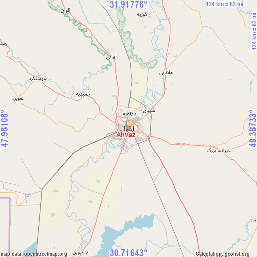
Ahvaz GPS coordinates[2]
31° 19' 8.436" North, 48° 41' 3.12" East
| Map corner | latitude | longitude |
|---|---|---|
| Upper-left | 31.91776°, | 47.98108° |
| Center: | 31.31901°, | 48.6842° |
| Lower-right: | 30.71643°, | 49.38733° |
| Map W x H: | 133.6×133.6 km | = 83×83mi |
| max Lat: | 39.6482° ⇑74.1% North |
| Ahvaz: | 31.31901° |
| min Lat: | ⇓25.9% South 25.2919° |
| min Long | Ahvaz | max Long |
| 44.38416° | 48.6842° | 61.9965° |
| W 25.6%⇐ | ⇒74.4% E |
Elevation
Elevation of Ahvaz is 23 m = 75 ft, and this is 1026 m = 3366 ft below average elevation for this country.
| Max E: |
2564 m = 8412 ft | 88.4% |
| Avg. | 1049 m = 3442 ft | |
| Ahvaz | 23 m = 75 ft | |
Min E: |
-24 m = -79 ft | 11.6% |
See also: Ahvaz elevation on elevation.city.
Geographical zone
Ahvaz is located in North temperate zone (between Tropic of Cancer and the Arctic Circle). Distance of this Northern Tropic circle is 876.4 km =544.6 mi to South.| Distance of | km | miles | from Ahvaz |
|---|---|---|---|
| North Pole | 6524.7 | 4054.3 | to North |
| Arctic Circle | 3918.8 | 2435 | to North |
| Tropic Cancer | 876.4 | 544.6 | to South |
| Equator | 3482.3 | 2163.8 | to South |


Nearby cities:
15 places around Ahvaz: (largest is in red/bold)
• Bandar-e Emam Khomeyni
105.9 km =65.8 mi,  157°
157°
• Bandar-e Māhshahr
97.5 km =60.6 mi,  150°
150°
• Haftkel
81.5 km =50.6 mi,  79°
79°
• Hoveyzeh
60.1 km =37.3 mi,  285°
285°
• Jongīyeh
9.5 km =5.9 mi,  222°
222°
• Khorramshahr
108.7 km =67.5 mi,  206°
206°
• Masjed Soleymān
90.3 km =56.1 mi,  40°
40°
• Mollās̄ānī
35.2 km =21.9 mi,  32°
32°
• Rāmhormoz
87.4 km =54.3 mi,  92°
92°
• Rāmshīr
83.6 km =51.9 mi,  124°
124°
• Shādegān
74.5 km =46.3 mi,  181°
181°
• Shūsh
105.9 km =65.8 mi,  336°
336°
• Shūshtar
82.7 km =51.4 mi,  10°
10°
• Sūsangerd
54.2 km =33.7 mi,  300°
300°
• sedeyen-e Yek
13.6 km =8.5 mi,  69°
69°
Sources, notices
• [Note1] Compared only with cities in Iran existing in our database
• [Src1] Map data: © OpenStreetMap contributors (CC-BY-SA)
• [Src2] Other city data from geonames.org with taken over terms of usage.
• [Src3] Geographical zone / Annual Mean Temperature by Robert A. Rohde @ Wikipedia
