Maku geodata
Maku (West Azerbaijan) is a seat of a second-order administrative division; located in Iran in Asia/Tehran (GMT+3.5) time zone. In our database, there are 232 cities with bigger population. Compared to other cities in Iran, 99.3% of cities are located further ↓South; 99.8% of cities are located further →East and 54% of cities have lower elevation than Maku. Note1


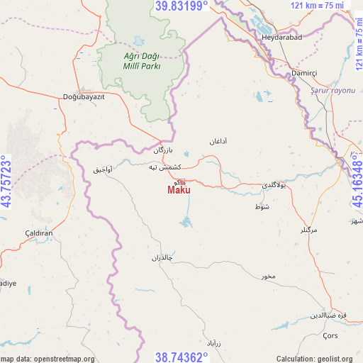
Maku GPS coordinates[2]
39° 17' 23.712" North, 44° 27' 37.26" East
| Map corner | latitude | longitude |
|---|---|---|
| Upper-left | 39.83199°, | 43.75723° |
| Center: | 39.28992°, | 44.46035° |
| Lower-right: | 38.74362°, | 45.16348° |
| Map W x H: | 121×121 km | = 75.2×75.2mi |
| max Lat: | 39.6482° ⇑0.7% North |
| Maku: | 39.28992° |
| min Lat: | ⇓99.3% South 25.2919° |
| min Long | Maku | max Long |
| 44.38416° | 44.46035° | 61.9965° |
| W 0.2%⇐ | ⇒99.8% E |
Elevation
Elevation of Maku is 1228 m = 4029 ft, and this is 179 m = 587 ft above average elevation for this country.
| Max E: |
2564 m = 8412 ft | 46% |
| Maku | 1228 m 4029 ft | |
| Avg. | 1049 m = 3442 ft | |
Min E: |
-24 m = -79 ft | 54% |
See also: Iran elevation on elevation.city.
Geographical zone
Maku is located in North temperate zone (between Tropic of Cancer and the Arctic Circle). Distance of this Northern Tropic circle is 1762.7 km =1095.3 mi to South.| Distance of | km | miles | from Maku |
|---|---|---|---|
| North Pole | 5638.4 | 3503.5 | to North |
| Arctic Circle | 3032.5 | 1884.3 | to North |
| Tropic Cancer | 1762.7 | 1095.3 | to South |
| Equator | 4368.6 | 2714.5 | to South |


Nearby cities:
15 places around Maku: (largest is in red/bold)
• Khomārlū
222.3 km =138.1 mi,  94°
94°
• Khowy
92.6 km =57.5 mi,  152°
152°
• Marand
148.4 km =92.2 mi,  129°
129°
• Mīāb
133.1 km =82.7 mi,  119°
119°
• Orūmīyeh
200.5 km =124.6 mi,  164°
164°
• Oskū
210.3 km =130.7 mi,  136°
136°
• Poldasht
52.9 km =32.9 mi,  82°
82°
• Qarah Ẕīā’ od Dīn
65.9 km =40.9 mi, 132°
• Salmās
124.3 km =77.2 mi,  167°
167°
• Seyah Cheshmeh
25.8 km =16 mi,  194°
194°
• Shabestar
163.8 km =101.8 mi, 138°
• Showţ
27.8 km =17.3 mi,  106°
106°
• Tabriz
208.2 km =129.4 mi, 130°
• Varazqān
158.3 km =98.4 mi, 115°
• Āz̄arshahr
215.4 km =133.8 mi, 142°
Sources, notices
• [Note1] Compared only with cities in Iran existing in our database
• [Src1] Map data: © OpenStreetMap contributors (CC-BY-SA)
• [Src2] Other city data from geonames.org with taken over terms of usage.
• [Src3] Geographical zone / Annual Mean Temperature by Robert A. Rohde @ Wikipedia
