Khowy geodata
Khowy (West Azerbaijan) is a seat of a second-order administrative division; located in Iran in Asia/Tehran (GMT+3.5) time zone. With population of 175,370 people, there are 45 cities with bigger population in this country. Compared to other cities in Iran, 97.3% of cities are located further ↓South; 99.1% of cities are located further →East and 52.2% of cities have higher elevation than Khowy. Note1


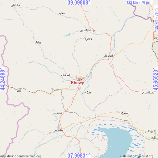
Khowy GPS coordinates[2]
38° 33' 1.08" North, 44° 57' 7.56" East
| Map corner | latitude | longitude |
|---|---|---|
| Upper-left | 39.09808°, | 44.24898° |
| Center: | 38.5503°, | 44.9521° |
| Lower-right: | 37.99831°, | 45.65523° |
| Map W x H: | 122.3×122.3 km | = 76×76mi |
| max Lat: | 39.6482° ⇑2.7% North |
| Khowy: | 38.5503° |
| min Lat: | ⇓97.3% South 25.2919° |
| min Long | Khowy | max Long |
| 44.38416° | 44.9521° | 61.9965° |
| W 0.9%⇐ | ⇒99.1% E |
Elevation
Elevation of Khowy is 1143 m = 3750 ft, and this is 94 m = 308 ft above average elevation for this country.
| Max E: |
2564 m = 8412 ft | 52.2% |
| Khowy | 1143 m 3750 ft | |
| Avg. | 1049 m = 3442 ft | |
Min E: |
-24 m = -79 ft | 47.8% |
See also: Khowy elevation on elevation.city.
Geographical zone
Khowy is located in North temperate zone (between Tropic of Cancer and the Arctic Circle). Distance of this Northern Tropic circle is 1680.5 km =1044.2 mi to South.| Distance of | km | miles | from Khowy |
|---|---|---|---|
| North Pole | 5720.7 | 3554.7 | to North |
| Arctic Circle | 3114.8 | 1935.4 | to North |
| Tropic Cancer | 1680.5 | 1044.2 | to South |
| Equator | 4286.4 | 2663.4 | to South |


Nearby cities:
15 places around Khowy: (largest is in red/bold)
• Kandovān
141.1 km =87.7 mi,  126°
126°
• Maku
92.6 km =57.5 mi,  332°
332°
• Marand
72.8 km =45.2 mi,  100°
100°
• Mīāb
75.7 km =47 mi,  77°
77°
• Orūmīyeh
111.4 km =69.2 mi,  174°
174°
• Oskū
124.3 km =77.2 mi,  124°
124°
• Poldasht
89.3 km =55.5 mi,  6°
6°
• Qarah Ẕīā’ od Dīn
38.5 km =23.9 mi, 9°
• Salmās
42.5 km =26.4 mi,  202°
202°
• Seyah Cheshmeh
75.5 km =46.9 mi,  319°
319°
• Shabestar
77.3 km =48 mi, 122°
• Showţ
76 km =47.2 mi,  348°
348°
• Tabriz
128 km =79.5 mi,  114°
114°
• Varazqān
101.7 km =63.2 mi, 82°
• Āz̄arshahr
125.7 km =78.1 mi, 134°
Sources, notices
• [Note1] Compared only with cities in Iran existing in our database
• [Src1] Map data: © OpenStreetMap contributors (CC-BY-SA)
• [Src2] Other city data from geonames.org with taken over terms of usage.
• [Src3] Geographical zone / Annual Mean Temperature by Robert A. Rohde @ Wikipedia
