Bajestān geodata
Bajestān (Razavi Khorasan) is a seat of a second-order administrative division; located in Iran in Asia/Tehran (GMT+3.5) time zone. In our database, there are 232 cities with bigger population. Compared to other cities in Iran, 51.7% of cities are located further ↓South; 88.9% of cities are located further ←West and 55.1% of cities have lower elevation than Bajestān. Note1


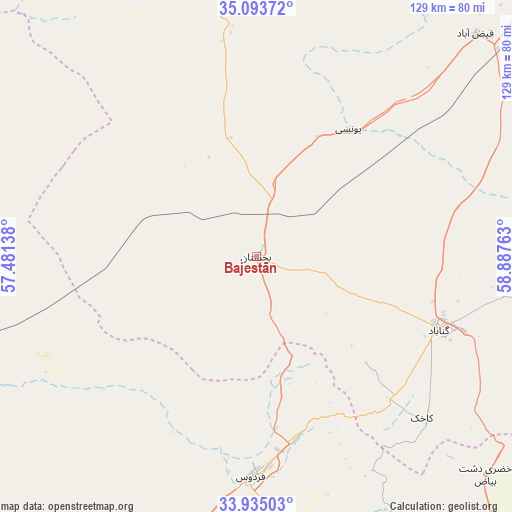
Bajestān GPS coordinates[2]
34° 30' 59.004" North, 58° 11' 4.2" East
| Map corner | latitude | longitude |
|---|---|---|
| Upper-left | 35.09372°, | 57.48138° |
| Center: | 34.51639°, | 58.1845° |
| Lower-right: | 33.93503°, | 58.88763° |
| Map W x H: | 128.8×128.8 km | = 80×80mi |
| max Lat: | 39.6482° ⇑48.3% North |
| Bajestān: | 34.51639° |
| min Lat: | ⇓51.7% South 25.2919° |
| min Long | Bajestān | max Long |
| 44.38416° | 58.1845° | 61.9965° |
| W 88.9%⇐ | ⇒11.1% E |
Elevation
Elevation of Bajestān is 1259 m = 4131 ft, and this is 210 m = 689 ft above average elevation for this country.
| Max E: |
2564 m = 8412 ft | 44.9% |
| Bajestān | 1259 m 4131 ft | |
| Avg. | 1049 m = 3442 ft | |
Min E: |
-24 m = -79 ft | 55.1% |
See also: Iran elevation on elevation.city.
Geographical zone
Bajestān is located in North temperate zone (between Tropic of Cancer and the Arctic Circle). Distance of this Northern Tropic circle is 1231.9 km =765.5 mi to South.| Distance of | km | miles | from Bajestān |
|---|---|---|---|
| North Pole | 6169.2 | 3833.4 | to North |
| Arctic Circle | 3563.3 | 2214.1 | to North |
| Tropic Cancer | 1231.9 | 765.5 | to South |
| Equator | 3837.9 | 2384.8 | to South |


Nearby cities:
15 places around Bajestān: (largest is in red/bold)
• Bardaskan
85.2 km =52.9 mi,  346°
346°
• Boshrūyeh
100.1 km =62.2 mi,  223°
223°
• Dowlatābād
148.6 km =92.3 mi,  55°
55°
• Ferdows
55.4 km =34.4 mi,  181°
181°
• Feyẕābād
78.2 km =48.6 mi,  44°
44°
• Gonābād
49.3 km =30.6 mi,  111°
111°
• Khalīlābād
82.5 km =51.3 mi,  6°
6°
• Khvāf
179.3 km =111.4 mi,  87°
87°
• Kāshmar
84.3 km =52.4 mi,  17°
17°
• Qā’en
127.2 km =79 mi,  133°
133°
• Roshtkhvār
141.1 km =87.7 mi,  68°
68°
• Sabzevar
194 km =120.5 mi, 346°
• Sarāyān
79.3 km =49.3 mi,  156°
156°
• Tabas
154.8 km =96.2 mi,  228°
228°
• Torbat-e Ḩeydarīyeh
126.5 km =78.6 mi,  48°
48°
Sources, notices
• [Note1] Compared only with cities in Iran existing in our database
• [Src1] Map data: © OpenStreetMap contributors (CC-BY-SA)
• [Src2] Other city data from geonames.org with taken over terms of usage.
• [Src3] Geographical zone / Annual Mean Temperature by Robert A. Rohde @ Wikipedia
