Roshtkhvār geodata
Roshtkhvār (Razavi Khorasan) is a seat of a second-order administrative division; located in Iran in Asia/Tehran (GMT+3.5) time zone. In our database, there are 232 cities with bigger population. Compared to other cities in Iran, 56% of cities are located further ↓South; 94.1% of cities are located further ←West and 51.5% of cities have higher elevation than Roshtkhvār. Note1


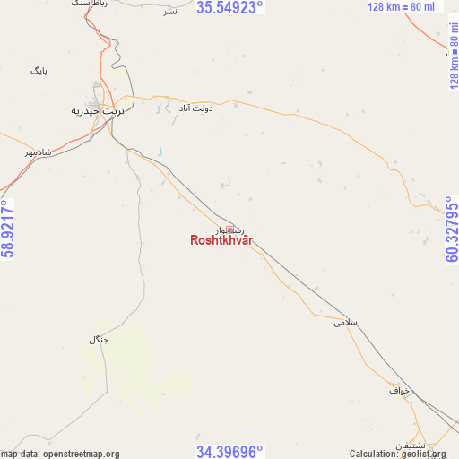
Roshtkhvār GPS coordinates[2]
34° 58' 30.432" North, 59° 37' 29.352" East
| Map corner | latitude | longitude |
|---|---|---|
| Upper-left | 35.54923°, | 58.9217° |
| Center: | 34.97512°, | 59.62482° |
| Lower-right: | 34.39696°, | 60.32795° |
| Map W x H: | 128.1×128.1 km | = 79.6×79.6mi |
| max Lat: | 39.6482° ⇑44% North |
| Roshtkhvār: | 34.97512° |
| min Lat: | ⇓56% South 25.2919° |
| min Long | Roshtkhvār | max Long |
| 44.38416° | 59.62482° | 61.9965° |
| W 94.1%⇐ | ⇒5.9% E |
Elevation
Elevation of Roshtkhvār is 1149 m = 3770 ft, and this is 100 m = 328 ft above average elevation for this country.
| Max E: |
2564 m = 8412 ft | 51.5% |
| Roshtkhvār | 1149 m 3770 ft | |
| Avg. | 1049 m = 3442 ft | |
Min E: |
-24 m = -79 ft | 48.5% |
See also: Iran elevation on elevation.city.
Geographical zone
Roshtkhvār is located in North temperate zone (between Tropic of Cancer and the Arctic Circle). Distance of this Northern Tropic circle is 1282.9 km =797.2 mi to South.| Distance of | km | miles | from Roshtkhvār |
|---|---|---|---|
| North Pole | 6118.2 | 3801.7 | to North |
| Arctic Circle | 3512.3 | 2182.4 | to North |
| Tropic Cancer | 1282.9 | 797.2 | to South |
| Equator | 3888.9 | 2416.4 | to South |


Nearby cities:
15 places around Roshtkhvār: (largest is in red/bold)
• Bajestān
141.1 km =87.7 mi,  248°
248°
• Dowlatābād
35.5 km =22.1 mi,  344°
344°
• Farīmān
83.9 km =52.1 mi,  14°
14°
• Feyẕābād
76.8 km =47.7 mi,  273°
273°
• Gonābād
110.4 km =68.6 mi,  231°
231°
• Khalīlābād
125.7 km =78.1 mi,  284°
284°
• Khvāf
64.7 km =40.2 mi,  133°
133°
• Kāshmar
109.4 km =68 mi,  285°
285°
• Mashhad
149.1 km =92.6 mi,  358°
358°
• Qā’en
144.6 km =89.9 mi,  196°
196°
• Shahrak-e Bākharz
63.1 km =39.2 mi,  88°
88°
• Torbat-e Jām
95.5 km =59.3 mi,  71°
71°
• Torbat-e Ḩeydarīyeh
49.6 km =30.8 mi,  312°
312°
• Tāybād
108.2 km =67.2 mi,  103°
103°
• Ţorqabeh
150.2 km =93.3 mi,  351°
351°
Sources, notices
• [Note1] Compared only with cities in Iran existing in our database
• [Src1] Map data: © OpenStreetMap contributors (CC-BY-SA)
• [Src2] Other city data from geonames.org with taken over terms of usage.
• [Src3] Geographical zone / Annual Mean Temperature by Robert A. Rohde @ Wikipedia
