Sarāyān geodata
Sarāyān (Khorāsān-e Jonūbī) is a seat of a second-order administrative division; located in Iran in Asia/Tehran (GMT+3.5) time zone. In our database, there are 232 cities with bigger population. Compared to other cities in Iran, 55.1% of cities are located further ↑North; 90.2% of cities are located further ←West and 67.6% of cities have lower elevation than Sarāyān. Note1


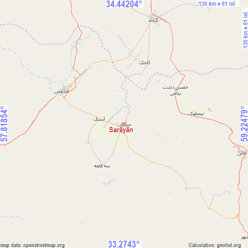
Sarāyān GPS coordinates[2]
33° 51' 36.612" North, 58° 31' 17.976" East
| Map corner | latitude | longitude |
|---|---|---|
| Upper-left | 34.44204°, | 57.81854° |
| Center: | 33.86017°, | 58.52166° |
| Lower-right: | 33.2743°, | 59.22479° |
| Map W x H: | 129.8×129.8 km | = 80.7×80.7mi |
| max Lat: | 39.6482° ⇑55.1% North |
| Sarāyān: | 33.86017° |
| min Lat: | ⇓44.9% South 25.2919° |
| min Long | Sarāyān | max Long |
| 44.38416° | 58.52166° | 61.9965° |
| W 90.2%⇐ | ⇒9.8% E |
Elevation
Elevation of Sarāyān is 1449 m = 4754 ft, and this is 400 m = 1312 ft above average elevation for this country.
| Max E: |
2564 m = 8412 ft | 32.4% |
| Sarāyān | 1449 m 4754 ft | |
| Avg. | 1049 m = 3442 ft | |
Min E: |
-24 m = -79 ft | 67.6% |
See also: Iran elevation on elevation.city.
Geographical zone
Sarāyān is located in North temperate zone (between Tropic of Cancer and the Arctic Circle). Distance of this Northern Tropic circle is 1159 km =720.2 mi to South.| Distance of | km | miles | from Sarāyān |
|---|---|---|---|
| North Pole | 6242.2 | 3878.7 | to North |
| Arctic Circle | 3636.3 | 2259.5 | to North |
| Tropic Cancer | 1159 | 720.2 | to South |
| Equator | 3764.9 | 2339.4 | to South |


Nearby cities:
15 places around Sarāyān: (largest is in red/bold)
• Asadīyeh
150.9 km =93.8 mi,  132°
132°
• Bajestān
79.3 km =49.3 mi,  336°
336°
• Bardaskan
163.8 km =101.8 mi, 342°
• Boshrūyeh
100.9 km =62.7 mi,  270°
270°
• Bīrjand
128.2 km =79.7 mi,  149°
149°
• Ferdows
36.7 km =22.8 mi,  298°
298°
• Feyẕābād
131.1 km =81.5 mi,  10°
10°
• Gonābād
56.8 km =35.3 mi,  15°
15°
• Khalīlābād
156.5 km =97.2 mi,  352°
352°
• Khvāf
168.8 km =104.9 mi,  61°
61°
• Kāshmar
153.3 km =95.3 mi,  358°
358°
• Qā’en
63 km =39.1 mi,  103°
103°
• Roshtkhvār
160 km =99.4 mi,  39°
39°
• Tabas
150.6 km =93.6 mi,  258°
258°
• Ḩājjīābād
139 km =86.4 mi, 101°
Sources, notices
• [Note1] Compared only with cities in Iran existing in our database
• [Src1] Map data: © OpenStreetMap contributors (CC-BY-SA)
• [Src2] Other city data from geonames.org with taken over terms of usage.
• [Src3] Geographical zone / Annual Mean Temperature by Robert A. Rohde @ Wikipedia
