Gonābād geodata
Gonābād (Razavi Khorasan) is a seat of a second-order administrative division; located in Iran in Asia/Tehran (GMT+3.5) time zone. With population of 43,465 people, there are 146 cities with bigger population in this country. Compared to other cities in Iran, 50.1% of cities are located further ↑North; 90.7% of cities are located further ←West and 53.5% of cities have higher elevation than Gonābād. Note1


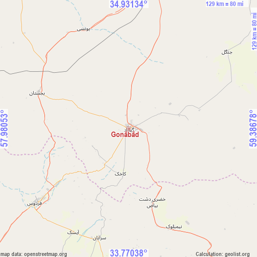
Gonābād GPS coordinates[2]
34° 21' 10.332" North, 58° 41' 1.14" East
| Map corner | latitude | longitude |
|---|---|---|
| Upper-left | 34.93134°, | 57.98053° |
| Center: | 34.35287°, | 58.68365° |
| Lower-right: | 33.77038°, | 59.38678° |
| Map W x H: | 129.1×129.1 km | = 80.2×80.2mi |
| max Lat: | 39.6482° ⇑50.1% North |
| Gonābād: | 34.35287° |
| min Lat: | ⇓49.9% South 25.2919° |
| min Long | Gonābād | max Long |
| 44.38416° | 58.68365° | 61.9965° |
| W 90.7%⇐ | ⇒9.3% E |
Elevation
Elevation of Gonābād is 1095 m = 3593 ft, and this is 46 m = 151 ft above average elevation for this country.
| Max E: |
2564 m = 8412 ft | 53.5% |
| Gonābād | 1095 m 3593 ft | |
| Avg. | 1049 m = 3442 ft | |
Min E: |
-24 m = -79 ft | 46.5% |
See also: Gonābād elevation on elevation.city.
Geographical zone
Gonābād is located in North temperate zone (between Tropic of Cancer and the Arctic Circle). Distance of this Northern Tropic circle is 1213.8 km =754.2 mi to South.| Distance of | km | miles | from Gonābād |
|---|---|---|---|
| North Pole | 6187.4 | 3844.7 | to North |
| Arctic Circle | 3581.5 | 2225.4 | to North |
| Tropic Cancer | 1213.8 | 754.2 | to South |
| Equator | 3819.7 | 2373.5 | to South |


Nearby cities:
15 places around Gonābād: (largest is in red/bold)
• Bajestān
49.3 km =30.6 mi,  291°
291°
• Bardaskan
120.2 km =74.7 mi,  327°
327°
• Boshrūyeh
127.5 km =79.2 mi,  245°
245°
• Dowlatābād
128.5 km =79.8 mi,  36°
36°
• Ferdows
60 km =37.3 mi,  231°
231°
• Feyẕābād
74.6 km =46.4 mi,  7°
7°
• Khalīlābād
106.6 km =66.2 mi,  340°
340°
• Khvāf
135.9 km =84.4 mi,  79°
79°
• Kāshmar
100.4 km =62.4 mi,  348°
348°
• Qā’en
83.5 km =51.9 mi,  146°
146°
• Roshtkhvār
110.4 km =68.6 mi,  51°
51°
• Sarāyān
56.8 km =35.3 mi,  195°
195°
• Shahrak-e Bākharz
165.4 km =102.8 mi,  64°
64°
• Torbat-e Ḩeydarīyeh
113.5 km =70.5 mi,  25°
25°
• Ḩājjīābād
146.6 km =91.1 mi,  124°
124°
Sources, notices
• [Note1] Compared only with cities in Iran existing in our database
• [Src1] Map data: © OpenStreetMap contributors (CC-BY-SA)
• [Src2] Other city data from geonames.org with taken over terms of usage.
• [Src3] Geographical zone / Annual Mean Temperature by Robert A. Rohde @ Wikipedia
