Tabas geodata
Tabas (Yazd) is a populated place; located in Iran in Asia/Tehran (GMT+3.5) time zone. With population of 49,993 people, there are 129 cities with bigger population in this country. Compared to other cities in Iran, 57.1% of cities are located further ↑North; 83.7% of cities are located further ←West and 70.1% of cities have higher elevation than Tabas. Note1


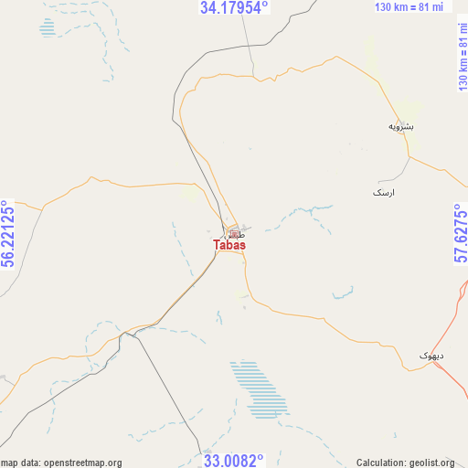
Tabas GPS coordinates[2]
33° 35' 45.096" North, 56° 55' 27.732" East
| Map corner | latitude | longitude |
|---|---|---|
| Upper-left | 34.17954°, | 56.22125° |
| Center: | 33.59586°, | 56.92437° |
| Lower-right: | 33.0082°, | 57.6275° |
| Map W x H: | 130.2×130.2 km | = 80.9×80.9mi |
| max Lat: | 39.6482° ⇑57.1% North |
| Tabas: | 33.59586° |
| min Lat: | ⇓42.9% South 25.2919° |
| min Long | Tabas | max Long |
| 44.38416° | 56.92437° | 61.9965° |
| W 83.7%⇐ | ⇒16.3% E |
Elevation
Elevation of Tabas is 669 m = 2195 ft, and this is 380 m = 1247 ft below average elevation for this country.
| Max E: |
2564 m = 8412 ft | 70.1% |
| Avg. | 1049 m = 3442 ft | |
| Tabas | 669 m = 2195 ft | |
Min E: |
-24 m = -79 ft | 29.9% |
See also: Tabas elevation on elevation.city.
Geographical zone
Tabas is located in North temperate zone (between Tropic of Cancer and the Arctic Circle). Distance of this Northern Tropic circle is 1129.6 km =701.9 mi to South.| Distance of | km | miles | from Tabas |
|---|---|---|---|
| North Pole | 6271.6 | 3897 | to North |
| Arctic Circle | 3665.7 | 2277.8 | to North |
| Tropic Cancer | 1129.6 | 701.9 | to South |
| Equator | 3735.5 | 2321.1 | to South |


Nearby cities:
15 places around Tabas: (largest is in red/bold)
• Bahābād
209.5 km =130.2 mi,  203°
203°
• Bajestān
154.8 km =96.2 mi,  48°
48°
• Bardaskan
208.7 km =129.7 mi,  27°
27°
• Boshrūyeh
55.6 km =34.5 mi,  56°
56°
• Bīrjand
228.5 km =142 mi,  110°
110°
• Ferdows
124.5 km =77.4 mi,  67°
67°
• Feyẕābād
232.8 km =144.7 mi, 47°
• Gonābād
182.8 km =113.6 mi, 62°
• Khalīlābād
222.7 km =138.4 mi, 34°
• Khūr
171.5 km =106.6 mi,  276°
276°
• Kāshmar
230.9 km =143.5 mi,  37°
37°
• Kūhbanān
250.4 km =155.6 mi,  193°
193°
• Qā’en
209.7 km =130.3 mi,  86°
86°
• Rāvar
259.3 km =161.1 mi,  182°
182°
• Sarāyān
150.6 km =93.6 mi,  78°
78°
Sources, notices
• [Note1] Compared only with cities in Iran existing in our database
• [Src1] Map data: © OpenStreetMap contributors (CC-BY-SA)
• [Src2] Other city data from geonames.org with taken over terms of usage.
• [Src3] Geographical zone / Annual Mean Temperature by Robert A. Rohde @ Wikipedia
