Khvāf geodata
Khvāf (Razavi Khorasan) is a seat of a second-order administrative division; located in Iran in Asia/Tehran (GMT+3.5) time zone. In our database, there are 232 cities with bigger population. Compared to other cities in Iran, 52.4% of cities are located further ↓South; 96.1% of cities are located further ←West and 60.1% of cities have higher elevation than Khvāf. Note1


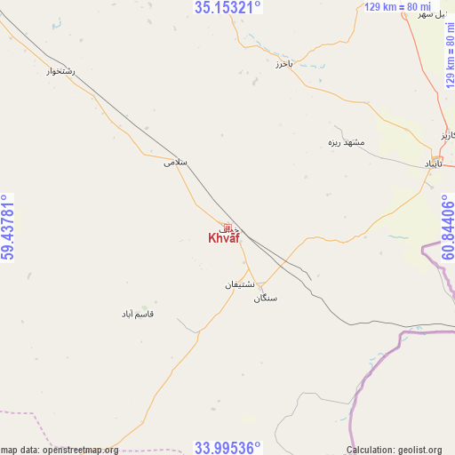
Khvāf GPS coordinates[2]
34° 34' 34.68" North, 60° 8' 27.348" East
| Map corner | latitude | longitude |
|---|---|---|
| Upper-left | 35.15321°, | 59.43781° |
| Center: | 34.5763°, | 60.14093° |
| Lower-right: | 33.99536°, | 60.84406° |
| Map W x H: | 128.7×128.7 km | = 80×80mi |
| max Lat: | 39.6482° ⇑47.6% North |
| Khvāf: | 34.5763° |
| min Lat: | ⇓52.4% South 25.2919° |
| min Long | Khvāf | max Long |
| 44.38416° | 60.14093° | 61.9965° |
| W 96.1%⇐ | ⇒3.9% E |
Elevation
Elevation of Khvāf is 975 m = 3199 ft, and this is 74 m = 243 ft below average elevation for this country.
| Max E: |
2564 m = 8412 ft | 60.1% |
| Avg. | 1049 m = 3442 ft | |
| Khvāf | 975 m = 3199 ft | |
Min E: |
-24 m = -79 ft | 39.9% |
See also: Iran elevation on elevation.city.
Geographical zone
Khvāf is located in North temperate zone (between Tropic of Cancer and the Arctic Circle). Distance of this Northern Tropic circle is 1238.6 km =769.6 mi to South.| Distance of | km | miles | from Khvāf |
|---|---|---|---|
| North Pole | 6162.5 | 3829.2 | to North |
| Arctic Circle | 3556.6 | 2210 | to North |
| Tropic Cancer | 1238.6 | 769.6 | to South |
| Equator | 3844.5 | 2388.9 | to South |


Nearby cities:
15 places around Khvāf: (largest is in red/bold)
• Bajestān
179.3 km =111.4 mi,  267°
267°
• Dowlatābād
96.8 km =60.1 mi,  324°
324°
• Farīmān
128.5 km =79.8 mi,  348°
348°
• Feyẕābād
133.4 km =82.9 mi,  291°
291°
• Gonābād
135.9 km =84.4 mi,  259°
259°
• Khalīlābād
185.2 km =115.1 mi, 294°
• Kāshmar
169.6 km =105.4 mi,  295°
295°
• Qā’en
129.1 km =80.2 mi,  222°
222°
• Roshtkhvār
64.7 km =40.2 mi,  313°
313°
• Sarāyān
168.8 km =104.9 mi,  241°
241°
• Shahrak-e Bākharz
48.9 km =30.4 mi,  19°
19°
• Torbat-e Jām
86.3 km =53.6 mi,  30°
30°
• Torbat-e Ḩeydarīyeh
114.3 km =71 mi, 312°
• Tāybād
60.8 km =37.8 mi,  72°
72°
• Ḩājjīābād
108.9 km =67.7 mi,  187°
187°
Sources, notices
• [Note1] Compared only with cities in Iran existing in our database
• [Src1] Map data: © OpenStreetMap contributors (CC-BY-SA)
• [Src2] Other city data from geonames.org with taken over terms of usage.
• [Src3] Geographical zone / Annual Mean Temperature by Robert A. Rohde @ Wikipedia
