Tūyserkān geodata
Tūyserkān (Hamadān) is a seat of a second-order administrative division; located in Iran in Asia/Tehran (GMT+3.5) time zone. In our database, there are 232 cities with bigger population. Compared to other cities in Iran, 52.2% of cities are located further ↓South; 77.3% of cities are located further →East and 87.5% of cities have lower elevation than Tūyserkān. Note1


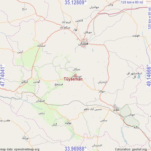
Tūyserkān GPS coordinates[2]
34° 33' 3.6" North, 48° 26' 36.708" East
| Map corner | latitude | longitude |
|---|---|---|
| Upper-left | 35.12809°, | 47.74041° |
| Center: | 34.551°, | 48.44353° |
| Lower-right: | 33.96988°, | 49.14666° |
| Map W x H: | 128.8×128.8 km | = 80×80mi |
| max Lat: | 39.6482° ⇑47.8% North |
| Tūyserkān: | 34.551° |
| min Lat: | ⇓52.2% South 25.2919° |
| min Long | Tūyserkān | max Long |
| 44.38416° | 48.44353° | 61.9965° |
| W 22.7%⇐ | ⇒77.3% E |
Elevation
Elevation of Tūyserkān is 1829 m = 6001 ft, and this is 780 m = 2559 ft above average elevation for this country.
| Max E: |
2564 m = 8412 ft | 12.5% |
| Tūyserkān | 1829 m 6001 ft | |
| Avg. | 1049 m = 3442 ft | |
Min E: |
-24 m = -79 ft | 87.5% |
See also: Iran elevation on elevation.city.
Geographical zone
Tūyserkān is located in North temperate zone (between Tropic of Cancer and the Arctic Circle). Distance of this Northern Tropic circle is 1235.8 km =767.9 mi to South.| Distance of | km | miles | from Tūyserkān |
|---|---|---|---|
| North Pole | 6165.4 | 3831 | to North |
| Arctic Circle | 3559.5 | 2211.8 | to North |
| Tropic Cancer | 1235.8 | 767.9 | to South |
| Equator | 3841.7 | 2387.1 | to South |


Nearby cities:
15 places around Tūyserkān: (largest is in red/bold)
• Anūch
50.7 km =31.5 mi,  166°
166°
• Asadābād
39.2 km =24.4 mi,  311°
311°
• Bahār
39.6 km =24.6 mi,  359°
359°
• Famast
57 km =35.4 mi,  178°
178°
• Hamadān
28.4 km =17.6 mi,  13°
13°
• Kabūdarāhang
77.5 km =48.2 mi,  19°
19°
• Kangāvar
44.1 km =27.4 mi,  263°
263°
• Khondāb
70.1 km =43.6 mi,  104°
104°
• Malāyer
44.4 km =27.6 mi,  128°
128°
• Nahāvand
40.5 km =25.2 mi,  188°
188°
• Nūrābād
68.5 km =42.6 mi,  219°
219°
• Pasragad Branch
25.3 km =15.7 mi, 5°
• pamas
57.1 km =35.5 mi, 178°
• Āzādshahr
29 km =18 mi, 23°
• Şaḩneh
69.4 km =43.1 mi, 263°
Sources, notices
• [Note1] Compared only with cities in Iran existing in our database
• [Src1] Map data: © OpenStreetMap contributors (CC-BY-SA)
• [Src2] Other city data from geonames.org with taken over terms of usage.
• [Src3] Geographical zone / Annual Mean Temperature by Robert A. Rohde @ Wikipedia
