Bāfq geodata
Bāfq (Yazd) is a seat of a second-order administrative division; located in Iran in Asia/Tehran (GMT+3.5) time zone. With population of 31,215 people, there are 173 cities with bigger population in this country. Compared to other cities in Iran, 71.4% of cities are located further ↑North; 78.5% of cities are located further ←West and 59.2% of cities have higher elevation than Bāfq. Note1


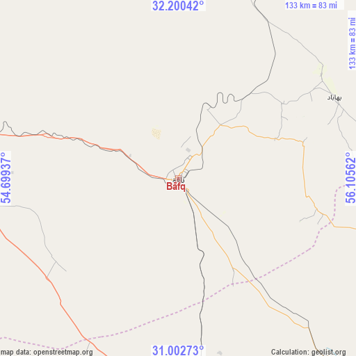
Bāfq GPS coordinates[2]
31° 36' 12.6" North, 55° 24' 8.964" East
| Map corner | latitude | longitude |
|---|---|---|
| Upper-left | 32.20042°, | 54.69937° |
| Center: | 31.6035°, | 55.40249° |
| Lower-right: | 31.00273°, | 56.10562° |
| Map W x H: | 133.2×133.2 km | = 82.8×82.8mi |
| max Lat: | 39.6482° ⇑71.4% North |
| Bāfq: | 31.6035° |
| min Lat: | ⇓28.6% South 25.2919° |
| min Long | Bāfq | max Long |
| 44.38416° | 55.40249° | 61.9965° |
| W 78.5%⇐ | ⇒21.5% E |
Elevation
Elevation of Bāfq is 991 m = 3251 ft, and this is 58 m = 190 ft below average elevation for this country.
| Max E: |
2564 m = 8412 ft | 59.2% |
| Avg. | 1049 m = 3442 ft | |
| Bāfq | 991 m = 3251 ft | |
Min E: |
-24 m = -79 ft | 40.8% |
See also: Iran elevation on elevation.city.
Geographical zone
Bāfq is located in North temperate zone (between Tropic of Cancer and the Arctic Circle). Distance of this Northern Tropic circle is 908.1 km =564.3 mi to South.| Distance of | km | miles | from Bāfq |
|---|---|---|---|
| North Pole | 6493.1 | 4034.6 | to North |
| Arctic Circle | 3887.2 | 2415.4 | to North |
| Tropic Cancer | 908.1 | 564.3 | to South |
| Equator | 3514 | 2183.5 | to South |


Nearby cities:
15 places around Bāfq: (largest is in red/bold)
• Anār
82.4 km =51.2 mi,  188°
188°
• Ardakān
152.5 km =94.8 mi,  301°
301°
• Bahābād
65.9 km =40.9 mi,  63°
63°
• Khavāş Kūh
180.8 km =112.3 mi, 295°
• Kūhbanān
86.1 km =53.5 mi,  104°
104°
• Mahrīz
90.9 km =56.5 mi,  268°
268°
• Meybod
149.2 km =92.7 mi, 298°
• Rafsanjān
144.5 km =89.8 mi,  157°
157°
• Rāvar
138.3 km =85.9 mi,  105°
105°
• Shahr-e Bābak
167.5 km =104.1 mi, 189°
• Shahrak-e Pābedānā
108 km =67.1 mi,  118°
118°
• Taft
113 km =70.2 mi,  278°
278°
• Taft
114.6 km =71.2 mi, 277°
• Yazd
103.2 km =64.1 mi,  288°
288°
• Zarand
141.2 km =87.7 mi,  128°
128°
Sources, notices
• [Note1] Compared only with cities in Iran existing in our database
• [Src1] Map data: © OpenStreetMap contributors (CC-BY-SA)
• [Src2] Other city data from geonames.org with taken over terms of usage.
• [Src3] Geographical zone / Annual Mean Temperature by Robert A. Rohde @ Wikipedia
