Miyazu geodata
Miyazu (Kyoto) is a seat of a second-order administrative division; located in Japan in Asia/Tokyo (GMT+9) time zone. With population of 21,632 people, there are 670 cities with bigger population in this country. Compared to other cities in Japan, 54.1% of cities are located further ↓South; 69.7% of cities are located further →East and 82.6% of cities have lower elevation than Miyazu. Note1


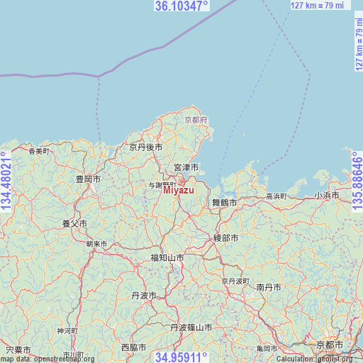
Miyazu GPS coordinates[2]
35° 31' 59.988" North, 135° 10' 59.988" East
| Map corner | latitude | longitude |
|---|---|---|
| Upper-left | 36.10347°, | 134.48021° |
| Center: | 35.53333°, | 135.18333° |
| Lower-right: | 34.95911°, | 135.88646° |
| Map W x H: | 127.2×127.2 km | = 79×79mi |
| max Lat: | 45.40944° ⇑45.9% North |
| Miyazu: | 35.53333° |
| min Lat: | ⇓54.1% South 24.34478° |
| min Long | Miyazu | max Long |
| 123° | 135.18333° | 145.575° |
| W 30.3%⇐ | ⇒69.7% E |
Elevation
Elevation of Miyazu is 146 m = 479 ft, and this is 61.4 m = 201 ft above average elevation for this country.
| Max E: |
1086 m = 3563 ft | 17.4% |
| Miyazu | 146 m 479 ft | |
| Avg. | 84.6 m = 278 ft | |
Min E: |
-2 m = -7 ft | 82.6% |
See also: Japan elevation on elevation.city.
Geographical zone
Miyazu is located in North temperate zone (between Tropic of Cancer and the Arctic Circle). Distance of this Northern Tropic circle is 1345 km =835.7 mi to South.| Distance of | km | miles | from Miyazu |
|---|---|---|---|
| North Pole | 6056.1 | 3763.1 | to North |
| Arctic Circle | 3450.2 | 2143.9 | to North |
| Tropic Cancer | 1345 | 835.7 | to South |
| Equator | 3950.9 | 2455 | to South |


Nearby cities:
15 places around Miyazu: (largest is in red/bold)
• Asago
45.3 km =28.1 mi,  227°
227°
• Ayabe
26.6 km =16.5 mi,  166°
166°
• Fukuchiyama
26.6 km =16.5 mi,  193°
193°
• Kameoka
69.5 km =43.2 mi,  148°
148°
• Katō
69.2 km =43 mi, 191°
• Kyōtango
15 km =9.3 mi,  302°
302°
• Maizuru
16.4 km =10.2 mi,  124°
124°
• Nantan
54.8 km =34.1 mi, 149°
• Nishiwaki
63.9 km =39.7 mi,  197°
197°
• Obama
51.1 km =31.8 mi,  94°
94°
• Sanda
65.2 km =40.5 mi,  177°
177°
• Sasayama
52 km =32.3 mi, 176°
• Tanba
43.5 km =27 mi, 197°
• Toyooka
32.8 km =20.4 mi,  271°
271°
• Yabu
40 km =24.9 mi,  248°
248°
Sources, notices
• [Note1] Compared only with cities in Japan existing in our database
• [Src1] Map data: © OpenStreetMap contributors (CC-BY-SA)
• [Src2] Other city data from geonames.org with taken over terms of usage.
• [Src3] Geographical zone / Annual Mean Temperature by Robert A. Rohde @ Wikipedia
