Kyōtango geodata
Kyōtango (Kyoto) is a seat of a second-order administrative division; located in Japan in Asia/Tokyo (GMT+9) time zone. In our database, there are 767 cities with bigger population. Compared to other cities in Japan, 55.2% of cities are located further ↓South; 70.4% of cities are located further →East and 66.4% of cities have lower elevation than Kyōtango. Note1


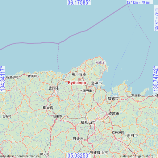
Kyōtango GPS coordinates[2]
35° 36' 22.428" North, 135° 2' 39.444" East
| Map corner | latitude | longitude |
|---|---|---|
| Upper-left | 36.17585°, | 134.34117° |
| Center: | 35.60623°, | 135.04429° |
| Lower-right: | 35.03253°, | 135.74742° |
| Map W x H: | 127.1×127.1 km | = 79×79mi |
| max Lat: | 45.40944° ⇑44.8% North |
| Kyōtango: | 35.60623° |
| min Lat: | ⇓55.2% South 24.34478° |
| min Long | Kyōtango | max Long |
| 123° | 135.04429° | 145.575° |
| W 29.6%⇐ | ⇒70.4% E |
Elevation
Elevation of Kyōtango is 61 m = 200 ft, and this is 23.6 m = 77 ft below average elevation for this country.
| Max E: |
1086 m = 3563 ft | 33.6% |
| Avg. | 84.6 m = 278 ft | |
| Kyōtango | 61 m = 200 ft | |
Min E: |
-2 m = -7 ft | 66.4% |
See also: Japan elevation on elevation.city.
Geographical zone
Kyōtango is located in North temperate zone (between Tropic of Cancer and the Arctic Circle). Distance of this Northern Tropic circle is 1353.1 km =840.8 mi to South.| Distance of | km | miles | from Kyōtango |
|---|---|---|---|
| North Pole | 6048 | 3758.1 | to North |
| Arctic Circle | 3442.1 | 2138.8 | to North |
| Tropic Cancer | 1353.1 | 840.8 | to South |
| Equator | 3959 | 2460 | to South |


Nearby cities:
15 places around Kyōtango: (largest is in red/bold)
• Asago
43.9 km =27.3 mi,  208°
208°
• Ayabe
38.8 km =24.1 mi,  151°
151°
• Fukuchiyama
34.7 km =21.6 mi,  169°
169°
• Katō
75.9 km =47.2 mi,  181°
181°
• Maizuru
31.4 km =19.5 mi,  123°
123°
• Miyazu
15 km =9.3 mi, 122°
• Nantan
68.5 km =42.6 mi,  143°
143°
• Nishiwaki
69.5 km =43.2 mi,  185°
185°
• Obama
64.7 km =40.2 mi,  100°
100°
• Sanda
74.9 km =46.5 mi, 168°
• Sasayama
62 km =38.5 mi, 165°
• Tanba
49.6 km =30.8 mi, 180°
• Tottori
74.3 km =46.2 mi,  260°
260°
• Toyooka
21.5 km =13.4 mi,  250°
250°
• Yabu
33.5 km =20.8 mi,  227°
227°
Sources, notices
• [Note1] Compared only with cities in Japan existing in our database
• [Src1] Map data: © OpenStreetMap contributors (CC-BY-SA)
• [Src2] Other city data from geonames.org with taken over terms of usage.
• [Src3] Geographical zone / Annual Mean Temperature by Robert A. Rohde @ Wikipedia
