Nyahururu geodata
Nyahururu (Laikipia) is a populated place; located in Kenya in Africa/Nairobi (GMT+3) time zone. With population of 31,978 people, there are 32 cities with bigger population in this country. Compared to other cities in Kenya, 65.8% of cities are located further ↓South; 54.4% of cities are located further →East and 97.4% of cities have lower elevation than Nyahururu. Note1


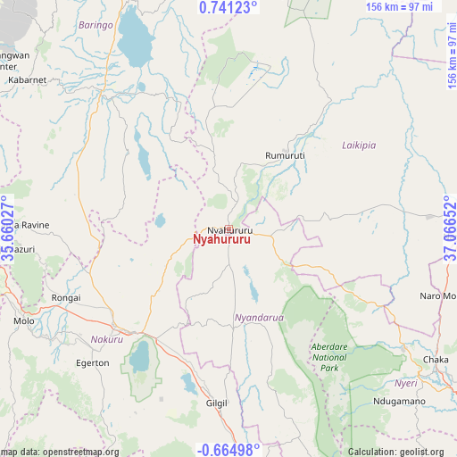
Nyahururu GPS coordinates[2]
0° 2' 17.268" North, 36° 21' 48.204" East
| Map corner | latitude | longitude |
|---|---|---|
| Upper-left | 0.74123°, | 35.66027° |
| Center: | 0.03813°, | 36.36339° |
| Lower-right: | -0.66498°, | 37.06652° |
| Map W x H: | 156.4×156.4 km | = 97.2×97.2mi |
| max Lat: | 3.93726° ⇑34.2% North |
| Nyahururu: | 0.03813° |
| min Lat: | ⇓65.8% South -4.64756° |
| min Long | Nyahururu | max Long |
| 33.97248° | 36.36339° | 41.85688° |
| W 45.6%⇐ | ⇒54.4% E |
Elevation
Elevation of Nyahururu is 2335 m = 7661 ft, and this is 988.3 m = 3242 ft above average elevation for this country.
| Max E: |
2514 m = 8248 ft | 2.6% |
| Nyahururu | 2335 m 7661 ft | |
| Avg. | 1346.7 m = 4418 ft | |
Min E: |
7 m = 23 ft | 97.4% |
See also: Kenya elevation on elevation.city.
Geographical zone
Nyahururu is located in North Torrid zone (between Equator and Tropic of Cancer). Distance of Equator is 4.2 km =2.6 mi to South.| Distance of | km | miles | from Nyahururu |
|---|---|---|---|
| North Pole | 10002.8 | 6215.4 | to North |
| Arctic Circle | 7396.9 | 4596.2 | to North |
| Tropic Cancer | 2601.7 | 1616.6 | to North |
| Equator | 4.2 | 2.6 | to South |


Nearby cities:
15 places around Nyahururu: (largest is in red/bold)
• Baringo
64.9 km =40.3 mi,  317°
317°
• Eldama Ravine
70.7 km =43.9 mi,  271°
271°
• Kabarnet
85.5 km =53.1 mi,  306°
306°
• Kipkelion
103.1 km =64.1 mi,  255°
255°
• Londiani
88.5 km =55 mi, 255°
• Molo
77.1 km =47.9 mi,  245°
245°
• Naivasha
84 km =52.2 mi,  174°
174°
• Nakuru
50.2 km =31.2 mi,  220°
220°
• Nanyuki
79.1 km =49.2 mi,  92°
92°
• Naro Moru
76.1 km =47.3 mi,  107°
107°
• Nyeri
82.6 km =51.3 mi,  128°
128°
• Ol Kalou
34.4 km =21.4 mi,  177°
177°
• Othaya
90.7 km =56.4 mi,  135°
135°
• Rongai
60.4 km =37.5 mi, 247°
• Rumuruti
32.5 km =20.2 mi,  36°
36°
Sources, notices
• [Note1] Compared only with cities in Kenya existing in our database
• [Src1] Map data: © OpenStreetMap contributors (CC-BY-SA)
• [Src2] Other city data from geonames.org with taken over terms of usage.
• [Src3] Geographical zone / Annual Mean Temperature by Robert A. Rohde @ Wikipedia
