Nakuru geodata
Nakuru is a seat of a first-order administrative division; located in Kenya in Africa/Nairobi (GMT+3) time zone. With population of 259,903 people, there are 2 cities with bigger population in this country. Compared to other cities in Kenya, 56.1% of cities are located further ↓South; 56.1% of cities are located further →East and 73.7% of cities have lower elevation than Nakuru. Note1


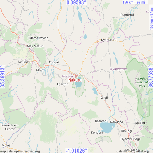
Nakuru GPS coordinates[2]
0° 18' 25.884" South, 36° 4' 20.1" East
| Map corner | latitude | longitude |
|---|---|---|
| Upper-left | 0.39593°, | 35.36913° |
| Center: | -0.30719°, | 36.07225° |
| Lower-right: | -1.01026°, | 36.77538° |
| Map W x H: | 156.4×156.4 km | = 97.2×97.2mi |
| max Lat: | 3.93726° ⇑43.9% North |
| Nakuru: | -0.30719° |
| min Lat: | ⇓56.1% South -4.64756° |
| min Long | Nakuru | max Long |
| 33.97248° | 36.07225° | 41.85688° |
| W 43.9%⇐ | ⇒56.1% E |
Elevation
Elevation of Nakuru is 1857 m = 6093 ft, and this is 510.3 m = 1674 ft above average elevation for this country.
| Max E: |
2514 m = 8248 ft | 26.3% |
| Nakuru | 1857 m 6093 ft | |
| Avg. | 1346.7 m = 4418 ft | |
Min E: |
7 m = 23 ft | 73.7% |
See also: Nakuru elevation on elevation.city.
Geographical zone
Nakuru is located in South Torrid zone (between Equator and Tropic of Capricorn). Distance of Equator is 34.2 km =21.3 mi to North.| Distance of | km | miles | from Nakuru |
|---|---|---|---|
| Equator | 34.2 | 21.3 | to North |
| Tropic Capricorn | 2571.8 | 1598 | to South |
| Antarctic Circle | 7367 | 4577.6 | to South |
| South Pole | 9972.9 | 6196.9 | to South |


Nearby cities:
15 places around Nakuru: (largest is in red/bold)
• Baringo
86.8 km =53.9 mi,  352°
352°
• Eldama Ravine
55.4 km =34.4 mi,  316°
316°
• Kabarnet
96.1 km =59.7 mi,  337°
337°
• Kericho
88 km =54.7 mi,  265°
265°
• Kijabe
89.1 km =55.4 mi,  141°
141°
• Kipkelion
68.3 km =42.4 mi,  280°
280°
• Londiani
55.5 km =34.5 mi,  286°
286°
• Molo
38.4 km =23.9 mi, 279°
• Naivasha
60.4 km =37.5 mi, 138°
• Narok
88.9 km =55.2 mi,  194°
194°
• Nyahururu
50.2 km =31.2 mi,  40°
40°
• Ol Kalou
34.4 km =21.4 mi,  83°
83°
• Rongai
27.6 km =17.1 mi,  302°
302°
• Rumuruti
82.7 km =51.4 mi, 38°
• Sotik Post
96.8 km =60.1 mi,  237°
237°
Sources, notices
• [Note1] Compared only with cities in Kenya existing in our database
• [Src1] Map data: © OpenStreetMap contributors (CC-BY-SA)
• [Src2] Other city data from geonames.org with taken over terms of usage.
• [Src3] Geographical zone / Annual Mean Temperature by Robert A. Rohde @ Wikipedia
