Nanyuki geodata
Nanyuki (Laikipia) is a populated place; located in Kenya in Africa/Nairobi (GMT+3) time zone. With population of 36,142 people, there are 24 cities with bigger population in this country. Compared to other cities in Kenya, 64.9% of cities are located further ↓South; 63.2% of cities are located further ←West and 84.2% of cities have lower elevation than Nanyuki. Note1


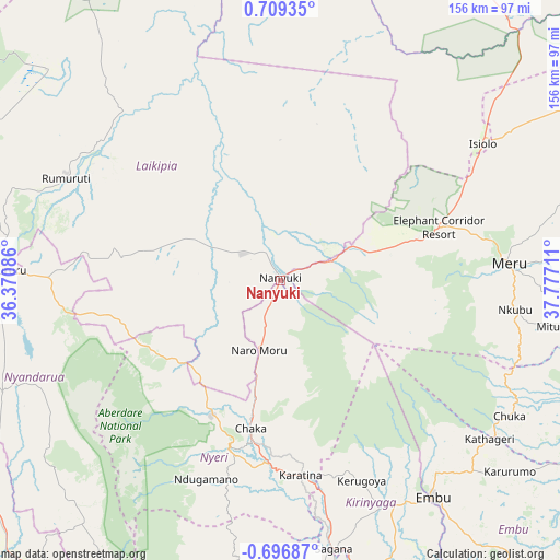
Nanyuki GPS coordinates[2]
0° 0' 22.464" North, 37° 4' 26.328" East
| Map corner | latitude | longitude |
|---|---|---|
| Upper-left | 0.70935°, | 36.37086° |
| Center: | 0.00624°, | 37.07398° |
| Lower-right: | -0.69687°, | 37.77711° |
| Map W x H: | 156.4×156.4 km | = 97.2×97.2mi |
| max Lat: | 3.93726° ⇑35.1% North |
| Nanyuki: | 0.00624° |
| min Lat: | ⇓64.9% South -4.64756° |
| min Long | Nanyuki | max Long |
| 33.97248° | 37.07398° | 41.85688° |
| W 63.2%⇐ | ⇒36.8% E |
Elevation
Elevation of Nanyuki is 2001 m = 6565 ft, and this is 654.3 m = 2147 ft above average elevation for this country.
| Max E: |
2514 m = 8248 ft | 15.8% |
| Nanyuki | 2001 m 6565 ft | |
| Avg. | 1346.7 m = 4418 ft | |
Min E: |
7 m = 23 ft | 84.2% |
See also: Kenya elevation on elevation.city.
Geographical zone
Nanyuki is located in North Torrid zone (between Equator and Tropic of Cancer). Distance of Equator is 0.7 km =0.4 mi to South.| Distance of | km | miles | from Nanyuki |
|---|---|---|---|
| North Pole | 10006.4 | 6217.7 | to North |
| Arctic Circle | 7400.5 | 4598.5 | to North |
| Tropic Cancer | 2605.2 | 1618.8 | to North |
| Equator | 0.7 | 0.4 | to South |


Nearby cities:
15 places around Nanyuki: (largest is in red/bold)
• Chuka
73.9 km =45.9 mi,  120°
120°
• Embu
74.2 km =46.1 mi,  144°
144°
• Isiolo
68.5 km =42.6 mi,  55°
55°
• Kangema
77.9 km =48.4 mi,  188°
188°
• Karuri
79.5 km =49.4 mi,  171°
171°
• Kerugoya
60.7 km =37.7 mi,  157°
157°
• Meru
64.9 km =40.3 mi,  86°
86°
• Murang’a
81.3 km =50.5 mi, 173°
• Naro Moru
19.9 km =12.4 mi,  198°
198°
• Nyahururu
79.1 km =49.2 mi,  272°
272°
• Nyeri
49.4 km =30.7 mi, 196°
• Ol Kalou
83.2 km =51.7 mi,  248°
248°
• Othaya
63.5 km =39.5 mi, 194°
• Rumuruti
66.5 km =41.3 mi,  296°
296°
• Sagana
76.5 km =47.5 mi, 168°
Sources, notices
• [Note1] Compared only with cities in Kenya existing in our database
• [Src1] Map data: © OpenStreetMap contributors (CC-BY-SA)
• [Src2] Other city data from geonames.org with taken over terms of usage.
• [Src3] Geographical zone / Annual Mean Temperature by Robert A. Rohde @ Wikipedia
