Rumuruti geodata
Rumuruti (Laikipia) is a seat of a first-order administrative division; located in Kenya in Africa/Nairobi (GMT+3) time zone. With population of 4,501 people, there are 90 cities with bigger population in this country. Compared to other cities in Kenya, 77.2% of cities are located further ↓South; 51.8% of cities are located further →East and 72.8% of cities have lower elevation than Rumuruti. Note1


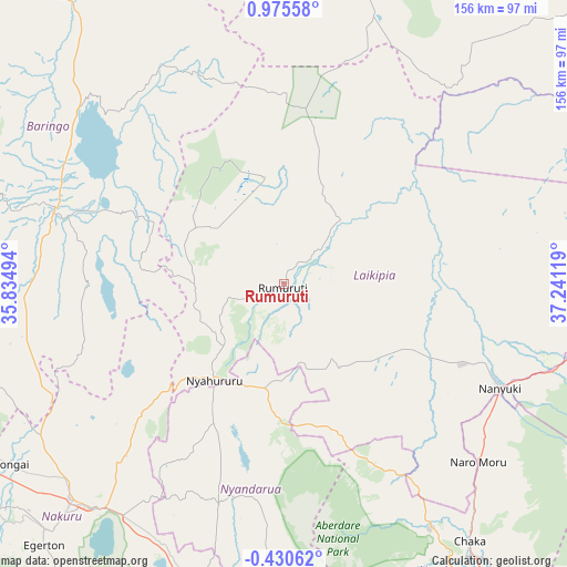
Rumuruti GPS coordinates[2]
0° 16' 21" North, 36° 32' 17.016" East
| Map corner | latitude | longitude |
|---|---|---|
| Upper-left | 0.97558°, | 35.83494° |
| Center: | 0.2725°, | 36.53806° |
| Lower-right: | -0.43062°, | 37.24119° |
| Map W x H: | 156.4×156.4 km | = 97.2×97.2mi |
| max Lat: | 3.93726° ⇑22.8% North |
| Rumuruti: | 0.2725° |
| min Lat: | ⇓77.2% South -4.64756° |
| min Long | Rumuruti | max Long |
| 33.97248° | 36.53806° | 41.85688° |
| W 48.2%⇐ | ⇒51.8% E |
Elevation
Elevation of Rumuruti is 1846 m = 6056 ft, and this is 499.3 m = 1638 ft above average elevation for this country.
| Max E: |
2514 m = 8248 ft | 27.2% |
| Rumuruti | 1846 m 6056 ft | |
| Avg. | 1346.7 m = 4418 ft | |
Min E: |
7 m = 23 ft | 72.8% |
See also: Kenya elevation on elevation.city.
Geographical zone
Rumuruti is located in North Torrid zone (between Equator and Tropic of Cancer). Distance of Equator is 30.3 km =18.8 mi to South.| Distance of | km | miles | from Rumuruti |
|---|---|---|---|
| North Pole | 9976.8 | 6199.3 | to North |
| Arctic Circle | 7370.9 | 4580.1 | to North |
| Tropic Cancer | 2575.6 | 1600.4 | to North |
| Equator | 30.3 | 18.8 | to South |


Nearby cities:
15 places around Rumuruti: (largest is in red/bold)
• Baringo
67.1 km =41.7 mi,  288°
288°
• Eldama Ravine
93.4 km =58 mi,  254°
254°
• Kabarnet
91.7 km =57 mi, 285°
• Londiani
115.8 km =72 mi, 245°
• Maralal
93.3 km =58 mi,  10°
10°
• Molo
106.7 km =66.3 mi,  237°
237°
• Naivasha
110.3 km =68.5 mi,  186°
186°
• Nakuru
82.7 km =51.4 mi,  218°
218°
• Nanyuki
66.5 km =41.3 mi,  116°
116°
• Naro Moru
72.1 km =44.8 mi,  132°
132°
• Nyahururu
32.5 km =20.2 mi, 216°
• Nyeri
89.5 km =55.6 mi,  149°
149°
• Ol Kalou
62.9 km =39.1 mi,  196°
196°
• Othaya
101 km =62.8 mi, 154°
• Rongai
89.9 km =55.9 mi, 236°
Sources, notices
• [Note1] Compared only with cities in Kenya existing in our database
• [Src1] Map data: © OpenStreetMap contributors (CC-BY-SA)
• [Src2] Other city data from geonames.org with taken over terms of usage.
• [Src3] Geographical zone / Annual Mean Temperature by Robert A. Rohde @ Wikipedia
