Othaya geodata
Othaya (Nyeri) is a populated place; located in Kenya in Africa/Nairobi (GMT+3) time zone. With population of 4,468 people, there are 91 cities with bigger population in this country. Compared to other cities in Kenya, 52.6% of cities are located further ↑North; 57% of cities are located further ←West and 75.4% of cities have lower elevation than Othaya. Note1


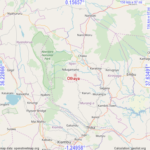
Othaya GPS coordinates[2]
0° 32' 47.58" South, 36° 55' 54.408" East
| Map corner | latitude | longitude |
|---|---|---|
| Upper-left | 0.15657°, | 36.22866° |
| Center: | -0.54655°, | 36.93178° |
| Lower-right: | -1.24958°, | 37.63491° |
| Map W x H: | 156.3×156.4 km | = 97.1×97.2mi |
| max Lat: | 3.93726° ⇑52.6% North |
| Othaya: | -0.54655° |
| min Lat: | ⇓47.4% South -4.64756° |
| min Long | Othaya | max Long |
| 33.97248° | 36.93178° | 41.85688° |
| W 57%⇐ | ⇒43% E |
Elevation
Elevation of Othaya is 1881 m = 6171 ft, and this is 534.3 m = 1753 ft above average elevation for this country.
| Max E: |
2514 m = 8248 ft | 24.6% |
| Othaya | 1881 m 6171 ft | |
| Avg. | 1346.7 m = 4418 ft | |
Min E: |
7 m = 23 ft | 75.4% |
See also: Kenya elevation on elevation.city.
Geographical zone
Othaya is located in South Torrid zone (between Equator and Tropic of Capricorn). Distance of Equator is 60.8 km =37.8 mi to North.| Distance of | km | miles | from Othaya |
|---|---|---|---|
| Equator | 60.8 | 37.8 | to North |
| Tropic Capricorn | 2545.1 | 1581.5 | to South |
| Antarctic Circle | 7340.4 | 4561.1 | to South |
| South Pole | 9946.3 | 6180.3 | to South |


Nearby cities:
15 places around Othaya: (largest is in red/bold)
• Embu
58.4 km =36.3 mi,  89°
89°
• Kandara
39.8 km =24.7 mi,  168°
168°
• Kangema
15.9 km =9.9 mi, 166°
• Karuri
32.8 km =20.4 mi,  121°
121°
• Kerugoya
39.1 km =24.3 mi,  82°
82°
• Kijabe
58.7 km =36.5 mi,  222°
222°
• Maragua
35.6 km =22.1 mi,  141°
141°
• Murang’a
31.3 km =19.4 mi,  128°
128°
• Naivasha
58.5 km =36.4 mi,  251°
251°
• Nanyuki
63.5 km =39.5 mi,  14°
14°
• Naro Moru
43.6 km =27.1 mi, 12°
• Nyeri
14.2 km =8.8 mi, 7°
• Ol Kalou
68.7 km =42.7 mi,  296°
296°
• Sagana
33.6 km =20.9 mi,  113°
113°
• Thika
56.2 km =34.9 mi,  164°
164°
Sources, notices
• [Note1] Compared only with cities in Kenya existing in our database
• [Src1] Map data: © OpenStreetMap contributors (CC-BY-SA)
• [Src2] Other city data from geonames.org with taken over terms of usage.
• [Src3] Geographical zone / Annual Mean Temperature by Robert A. Rohde @ Wikipedia
