Baringo geodata
Baringo is a populated place; located in Kenya in Africa/Nairobi (GMT+3) time zone. With population of 7,656 people, there are 77 cities with bigger population in this country. Compared to other cities in Kenya, 84.2% of cities are located further ↓South; 57% of cities are located further →East and 77.2% of cities have higher elevation than Baringo. Note1


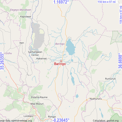
Baringo GPS coordinates[2]
0° 28' 0.012" North, 35° 58' 0.012" East
| Map corner | latitude | longitude |
|---|---|---|
| Upper-left | 1.16972°, | 35.26355° |
| Center: | 0.46667°, | 35.96667° |
| Lower-right: | -0.23645°, | 36.6698° |
| Map W x H: | 156.4×156.4 km | = 97.2×97.2mi |
| max Lat: | 3.93726° ⇑15.8% North |
| Baringo: | 0.46667° |
| min Lat: | ⇓84.2% South -4.64756° |
| min Long | Baringo | max Long |
| 33.97248° | 35.96667° | 41.85688° |
| W 43%⇐ | ⇒57% E |
Elevation
Elevation of Baringo is 1090 m = 3576 ft, and this is 256.7 m = 842 ft below average elevation for this country.
| Max E: |
2514 m = 8248 ft | 77.2% |
| Avg. | 1346.7 m = 4418 ft | |
| Baringo | 1090 m = 3576 ft | |
Min E: |
7 m = 23 ft | 22.8% |
See also: Kenya elevation on elevation.city.
Geographical zone
Baringo is located in North Torrid zone (between Equator and Tropic of Cancer). Distance of Equator is 51.9 km =32.2 mi to South.| Distance of | km | miles | from Baringo |
|---|---|---|---|
| North Pole | 9955.2 | 6185.9 | to North |
| Arctic Circle | 7349.3 | 4566.6 | to North |
| Tropic Cancer | 2554 | 1587 | to North |
| Equator | 51.9 | 32.2 | to South |


Nearby cities:
15 places around Baringo: (largest is in red/bold)
• Eldama Ravine
53.2 km =33.1 mi,  209°
209°
• Eldoret
77.7 km =48.3 mi,  274°
274°
• Iten
55.8 km =34.7 mi,  293°
293°
• Kabarnet
25 km =15.5 mi,  276°
276°
• Kapsabet
100.2 km =62.3 mi,  253°
253°
• Kapsowar
72.8 km =45.2 mi,  321°
321°
• Kipkelion
92.6 km =57.5 mi,  216°
216°
• Londiani
81.6 km =50.7 mi, 210°
• Molo
83.7 km =52 mi,  198°
198°
• Nakuru
86.8 km =53.9 mi,  172°
172°
• Nandi Hills
95.9 km =59.6 mi, 245°
• Nyahururu
64.9 km =40.3 mi,  137°
137°
• Ol Kalou
94 km =58.4 mi,  150°
150°
• Rongai
72.1 km =44.8 mi,  189°
189°
• Rumuruti
67.1 km =41.7 mi,  108°
108°
Sources, notices
• [Note1] Compared only with cities in Kenya existing in our database
• [Src1] Map data: © OpenStreetMap contributors (CC-BY-SA)
• [Src2] Other city data from geonames.org with taken over terms of usage.
• [Src3] Geographical zone / Annual Mean Temperature by Robert A. Rohde @ Wikipedia
