Naro Moru geodata
Naro Moru (Nyeri) is a populated place; located in Kenya in Africa/Nairobi (GMT+3) time zone. With population of 9,018 people, there are 72 cities with bigger population in this country. Compared to other cities in Kenya, 62.3% of cities are located further ↓South; 61.4% of cities are located further ←West and 86.8% of cities have lower elevation than Naro Moru. Note1


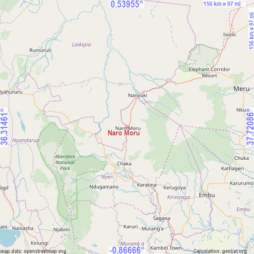
Naro Moru GPS coordinates[2]
0° 9' 48.852" South, 37° 1' 3.828" East
| Map corner | latitude | longitude |
|---|---|---|
| Upper-left | 0.53955°, | 36.31461° |
| Center: | -0.16357°, | 37.01773° |
| Lower-right: | -0.86666°, | 37.72086° |
| Map W x H: | 156.4×156.4 km | = 97.2×97.2mi |
| max Lat: | 3.93726° ⇑37.7% North |
| Naro Moru: | -0.16357° |
| min Lat: | ⇓62.3% South -4.64756° |
| min Long | Naro Moru | max Long |
| 33.97248° | 37.01773° | 41.85688° |
| W 61.4%⇐ | ⇒38.6% E |
Elevation
Elevation of Naro Moru is 2024 m = 6640 ft, and this is 677.3 m = 2222 ft above average elevation for this country.
| Max E: |
2514 m = 8248 ft | 13.2% |
| Naro Moru | 2024 m 6640 ft | |
| Avg. | 1346.7 m = 4418 ft | |
Min E: |
7 m = 23 ft | 86.8% |
See also: Kenya elevation on elevation.city.
Geographical zone
Naro Moru is located in South Torrid zone (between Equator and Tropic of Capricorn). Distance of Equator is 18.2 km =11.3 mi to North.| Distance of | km | miles | from Naro Moru |
|---|---|---|---|
| Equator | 18.2 | 11.3 | to North |
| Tropic Capricorn | 2587.7 | 1607.9 | to South |
| Antarctic Circle | 7383 | 4587.6 | to South |
| South Pole | 9988.9 | 6206.8 | to South |


Nearby cities:
15 places around Naro Moru: (largest is in red/bold)
• Chuka
72.3 km =44.9 mi,  105°
105°
• Embu
64.3 km =40 mi,  130°
130°
• Kangema
58.3 km =36.2 mi,  185°
185°
• Karuri
62.4 km =38.8 mi,  162°
162°
• Kerugoya
47.4 km =29.5 mi,  141°
141°
• Maragua
71.5 km =44.4 mi,  169°
169°
• Meru
74.7 km =46.4 mi,  71°
71°
• Murang’a
63.8 km =39.6 mi, 166°
• Nanyuki
19.9 km =12.4 mi,  18°
18°
• Nyahururu
76.1 km =47.3 mi,  287°
287°
• Nyeri
29.6 km =18.4 mi,  195°
195°
• Ol Kalou
72 km =44.7 mi,  260°
260°
• Othaya
43.6 km =27.1 mi, 192°
• Rumuruti
72.1 km =44.8 mi,  312°
312°
• Sagana
60 km =37.3 mi, 159°
Sources, notices
• [Note1] Compared only with cities in Kenya existing in our database
• [Src1] Map data: © OpenStreetMap contributors (CC-BY-SA)
• [Src2] Other city data from geonames.org with taken over terms of usage.
• [Src3] Geographical zone / Annual Mean Temperature by Robert A. Rohde @ Wikipedia
