Nyeri geodata
Nyeri is a seat of a first-order administrative division; located in Kenya in Africa/Nairobi (GMT+3) time zone. With population of 51,084 people, there are 13 cities with bigger population in this country. Compared to other cities in Kenya, 52.6% of cities are located further ↓South; 57.9% of cities are located further ←West and 71.9% of cities have lower elevation than Nyeri. Note1


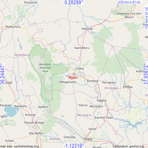
Nyeri GPS coordinates[2]
0° 25' 12.468" South, 36° 56' 51.324" East
| Map corner | latitude | longitude |
|---|---|---|
| Upper-left | 0.28299°, | 36.24447° |
| Center: | -0.42013°, | 36.94759° |
| Lower-right: | -1.12319°, | 37.65072° |
| Map W x H: | 156.4×156.4 km | = 97.2×97.2mi |
| max Lat: | 3.93726° ⇑47.4% North |
| Nyeri: | -0.42013° |
| min Lat: | ⇓52.6% South -4.64756° |
| min Long | Nyeri | max Long |
| 33.97248° | 36.94759° | 41.85688° |
| W 57.9%⇐ | ⇒42.1% E |
Elevation
Elevation of Nyeri is 1812 m = 5945 ft, and this is 465.3 m = 1527 ft above average elevation for this country.
| Max E: |
2514 m = 8248 ft | 28.1% |
| Nyeri | 1812 m 5945 ft | |
| Avg. | 1346.7 m = 4418 ft | |
Min E: |
7 m = 23 ft | 71.9% |
See also: Nyeri elevation on elevation.city.
Geographical zone
Nyeri is located in South Torrid zone (between Equator and Tropic of Capricorn). Distance of Equator is 46.7 km =29 mi to North.| Distance of | km | miles | from Nyeri |
|---|---|---|---|
| Equator | 46.7 | 29 | to North |
| Tropic Capricorn | 2559.2 | 1590.2 | to South |
| Antarctic Circle | 7354.5 | 4569.9 | to South |
| South Pole | 9960.3 | 6189 | to South |


Nearby cities:
15 places around Nyeri: (largest is in red/bold)
• Embu
58.2 km =36.2 mi,  103°
103°
• Kandara
53.4 km =33.2 mi,  173°
173°
• Kangema
29.6 km =18.4 mi,  176°
176°
• Karuri
40.7 km =25.3 mi,  139°
139°
• Kerugoya
38 km =23.6 mi, 103°
• Kijabe
70.7 km =43.9 mi,  216°
216°
• Maragua
46.6 km =29 mi,  153°
153°
• Murang’a
40.5 km =25.2 mi, 145°
• Naivasha
65.9 km =40.9 mi,  240°
240°
• Nanyuki
49.4 km =30.7 mi,  16°
16°
• Naro Moru
29.6 km =18.4 mi, 15°
• Ol Kalou
65.3 km =40.6 mi,  284°
284°
• Othaya
14.2 km =8.8 mi,  187°
187°
• Sagana
40 km =24.9 mi,  133°
133°
• Thika
69.5 km =43.2 mi, 168°
Sources, notices
• [Note1] Compared only with cities in Kenya existing in our database
• [Src1] Map data: © OpenStreetMap contributors (CC-BY-SA)
• [Src2] Other city data from geonames.org with taken over terms of usage.
• [Src3] Geographical zone / Annual Mean Temperature by Robert A. Rohde @ Wikipedia
