Iten geodata
Iten (Elegeyo-Marakwet) is a seat of a first-order administrative division; located in Kenya in Africa/Nairobi (GMT+3) time zone. With population of 42,000 people, there are 20 cities with bigger population in this country. Compared to other cities in Kenya, 90.4% of cities are located further ↓South; 64.9% of cities are located further →East and 99.1% of cities have lower elevation than Iten. Note1


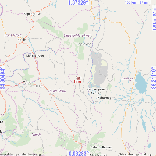
Iten GPS coordinates[2]
0° 40' 13.008" North, 35° 30' 29.016" East
| Map corner | latitude | longitude |
|---|---|---|
| Upper-left | 1.37329°, | 34.80494° |
| Center: | 0.67028°, | 35.50806° |
| Lower-right: | -0.03283°, | 36.21119° |
| Map W x H: | 156.3×156.3 km | = 97.1×97.1mi |
| max Lat: | 3.93726° ⇑9.6% North |
| Iten: | 0.67028° |
| min Lat: | ⇓90.4% South -4.64756° |
| min Long | Iten | max Long |
| 33.97248° | 35.50806° | 41.85688° |
| W 35.1%⇐ | ⇒64.9% E |
Elevation
Elevation of Iten is 2355 m = 7726 ft, and this is 1008.3 m = 3308 ft above average elevation for this country.
| Max E: |
2514 m = 8248 ft | 0.90000000000001% |
| Iten | 2355 m 7726 ft | |
| Avg. | 1346.7 m = 4418 ft | |
Min E: |
7 m = 23 ft | 99.1% |
See also: Iten elevation on elevation.city.
Geographical zone
Iten is located in North Torrid zone (between Equator and Tropic of Cancer). Distance of Equator is 74.5 km =46.3 mi to South.| Distance of | km | miles | from Iten |
|---|---|---|---|
| North Pole | 9932.5 | 6171.8 | to North |
| Arctic Circle | 7326.6 | 4552.5 | to North |
| Tropic Cancer | 2531.4 | 1572.9 | to North |
| Equator | 74.5 | 46.3 | to South |


Nearby cities:
15 places around Iten: (largest is in red/bold)
• Baringo
55.8 km =34.7 mi,  113°
113°
• Chepareria
78.4 km =48.7 mi,  334°
334°
• Eldama Ravine
72.9 km =45.3 mi,  160°
160°
• Eldoret
31.3 km =19.4 mi,  237°
237°
• Kabarnet
32.8 km =20.4 mi,  127°
127°
• Kakamega
94.4 km =58.7 mi, 242°
• Kapenguria
77 km =47.8 mi, 325°
• Kapsabet
68.5 km =42.6 mi,  220°
220°
• Kapsowar
34.8 km =21.6 mi,  9°
9°
• Kipkelion
96.9 km =60.2 mi,  182°
182°
• Kitale
67.7 km =42.1 mi,  304°
304°
• Londiani
93.4 km =58 mi,  174°
174°
• Muhoroni
98.4 km =61.1 mi,  200°
200°
• Nandi Hills
72.6 km =45.1 mi,  209°
209°
• Webuye
82.3 km =51.1 mi,  264°
264°
Sources, notices
• [Note1] Compared only with cities in Kenya existing in our database
• [Src1] Map data: © OpenStreetMap contributors (CC-BY-SA)
• [Src2] Other city data from geonames.org with taken over terms of usage.
• [Src3] Geographical zone / Annual Mean Temperature by Robert A. Rohde @ Wikipedia
