Eldoret geodata
Eldoret (Uasin Gishu) is a seat of a first-order administrative division; located in Kenya in Africa/Nairobi (GMT+3) time zone. With population of 218,446 people, there are 3 cities with bigger population in this country. Compared to other cities in Kenya, 86% of cities are located further ↓South; 68.4% of cities are located further →East and 93.9% of cities have lower elevation than Eldoret. Note1


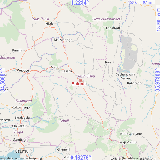
Eldoret GPS coordinates[2]
0° 31' 13.296" North, 35° 16' 11.748" East
| Map corner | latitude | longitude |
|---|---|---|
| Upper-left | 1.2234°, | 34.56681° |
| Center: | 0.52036°, | 35.26993° |
| Lower-right: | -0.18276°, | 35.97306° |
| Map W x H: | 156.4×156.4 km | = 97.2×97.2mi |
| max Lat: | 3.93726° ⇑14% North |
| Eldoret: | 0.52036° |
| min Lat: | ⇓86% South -4.64756° |
| min Long | Eldoret | max Long |
| 33.97248° | 35.26993° | 41.85688° |
| W 31.6%⇐ | ⇒68.4% E |
Elevation
Elevation of Eldoret is 2095 m = 6873 ft, and this is 748.3 m = 2455 ft above average elevation for this country.
| Max E: |
2514 m = 8248 ft | 6.1% |
| Eldoret | 2095 m 6873 ft | |
| Avg. | 1346.7 m = 4418 ft | |
Min E: |
7 m = 23 ft | 93.9% |
See also: Eldoret elevation on elevation.city.
Geographical zone
Eldoret is located in North Torrid zone (between Equator and Tropic of Cancer). Distance of Equator is 57.9 km =36 mi to South.| Distance of | km | miles | from Eldoret |
|---|---|---|---|
| North Pole | 9949.2 | 6182.1 | to North |
| Arctic Circle | 7343.3 | 4562.9 | to North |
| Tropic Cancer | 2548.1 | 1583.3 | to North |
| Equator | 57.9 | 36 | to South |


Nearby cities:
15 places around Eldoret: (largest is in red/bold)
• Baringo
77.7 km =48.3 mi,  94°
94°
• Bungoma
76.7 km =47.7 mi,  275°
275°
• Bungoma
79 km =49.1 mi,  273°
273°
• Eldama Ravine
72.8 km =45.2 mi,  135°
135°
• Iten
31.3 km =19.4 mi,  57°
57°
• Kabarnet
52.7 km =32.7 mi, 93°
• Kakamega
63.3 km =39.3 mi,  245°
245°
• Kapenguria
81.8 km =50.8 mi,  347°
347°
• Kapsabet
39.7 km =24.7 mi,  207°
207°
• Kapsowar
60.2 km =37.4 mi,  32°
32°
• Kitale
62.4 km =38.8 mi,  331°
331°
• Mbale
78.1 km =48.5 mi,  231°
231°
• Muhoroni
75.9 km =47.2 mi,  186°
186°
• Nandi Hills
47.3 km =29.4 mi, 191°
• Webuye
56.2 km =34.9 mi, 279°
Sources, notices
• [Note1] Compared only with cities in Kenya existing in our database
• [Src1] Map data: © OpenStreetMap contributors (CC-BY-SA)
• [Src2] Other city data from geonames.org with taken over terms of usage.
• [Src3] Geographical zone / Annual Mean Temperature by Robert A. Rohde @ Wikipedia
