Murang’a geodata
Murang’a (Murang'A) is a seat of a first-order administrative division; located in Kenya in Africa/Nairobi (GMT+3) time zone. With population of 11,987 people, there are 59 cities with bigger population in this country. Compared to other cities in Kenya, 60.5% of cities are located further ↑North; 65.8% of cities are located further ←West and 58.8% of cities have higher elevation than Murang’a. Note1


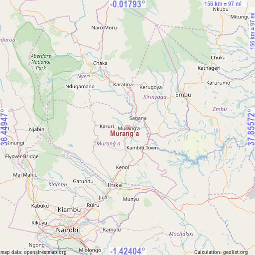
Murang’a GPS coordinates[2]
0° 43' 15.744" South, 37° 9' 9.324" East
| Map corner | latitude | longitude |
|---|---|---|
| Upper-left | -0.01793°, | 36.44947° |
| Center: | -0.72104°, | 37.15259° |
| Lower-right: | -1.42404°, | 37.85572° |
| Map W x H: | 156.3×156.3 km | = 97.1×97.1mi |
| max Lat: | 3.93726° ⇑60.5% North |
| Murang’a: | -0.72104° |
| min Lat: | ⇓39.5% South -4.64756° |
| min Long | Murang’a | max Long |
| 33.97248° | 37.15259° | 41.85688° |
| W 65.8%⇐ | ⇒34.2% E |
Elevation
Elevation of Murang’a is 1318 m = 4324 ft, and this is 28.7 m = 94 ft below average elevation for this country.
| Max E: |
2514 m = 8248 ft | 58.8% |
| Avg. | 1346.7 m = 4418 ft | |
| Murang’a | 1318 m = 4324 ft | |
Min E: |
7 m = 23 ft | 41.2% |
See also: Kenya elevation on elevation.city.
Geographical zone
Murang’a is located in South Torrid zone (between Equator and Tropic of Capricorn). Distance of Equator is 80.2 km =49.8 mi to North.| Distance of | km | miles | from Murang’a |
|---|---|---|---|
| Equator | 80.2 | 49.8 | to North |
| Tropic Capricorn | 2525.7 | 1569.4 | to South |
| Antarctic Circle | 7321 | 4549.1 | to South |
| South Pole | 9926.9 | 6168.3 | to South |


Nearby cities:
15 places around Murang’a: (largest is in red/bold)
• Chuka
69.8 km =43.4 mi,  51°
51°
• Embu
39.4 km =24.5 mi,  59°
59°
• Kandara
25.7 km =16 mi,  220°
220°
• Kangema
21.3 km =13.2 mi,  280°
280°
• Kangundo
68.3 km =42.4 mi,  161°
161°
• Karuri
4.1 km =2.5 mi, 55°
• Kerugoya
28.5 km =17.7 mi,  29°
29°
• Kiambu
61.2 km =38 mi, 215°
• Kijabe
68.7 km =42.7 mi,  249°
249°
• Maragua
8.6 km =5.3 mi,  194°
194°
• Naro Moru
63.8 km =39.6 mi,  346°
346°
• Nyeri
40.5 km =25.2 mi,  325°
325°
• Othaya
31.3 km =19.4 mi,  308°
308°
• Sagana
8.6 km =5.3 mi, 46°
• Thika
35.9 km =22.3 mi, 194°
Sources, notices
• [Note1] Compared only with cities in Kenya existing in our database
• [Src1] Map data: © OpenStreetMap contributors (CC-BY-SA)
• [Src2] Other city data from geonames.org with taken over terms of usage.
• [Src3] Geographical zone / Annual Mean Temperature by Robert A. Rohde @ Wikipedia
