Karuri geodata
Karuri (Murang'A) is a populated place; located in Kenya in Africa/Nairobi (GMT+3) time zone. With population of 21,476 people, there are 42 cities with bigger population in this country. Compared to other cities in Kenya, 58.8% of cities are located further ↑North; 66.7% of cities are located further ←West and 66.7% of cities have higher elevation than Karuri. Note1


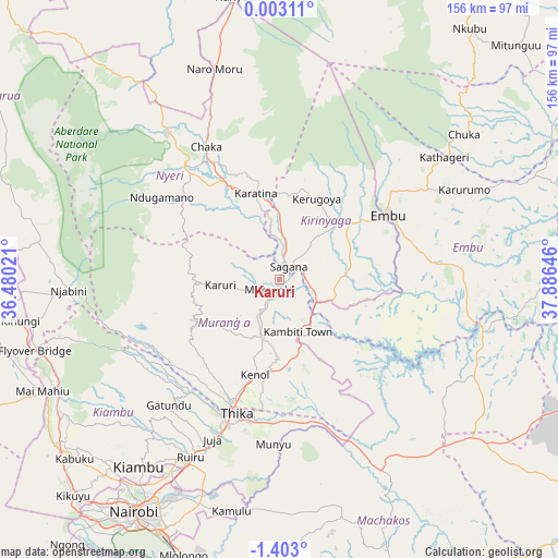
Karuri GPS coordinates[2]
0° 42' 0" South, 37° 10' 59.988" East
| Map corner | latitude | longitude |
|---|---|---|
| Upper-left | 0.00311°, | 36.48021° |
| Center: | -0.7°, | 37.18333° |
| Lower-right: | -1.403°, | 37.88646° |
| Map W x H: | 156.3×156.3 km | = 97.1×97.1mi |
| max Lat: | 3.93726° ⇑58.8% North |
| Karuri: | -0.7° |
| min Lat: | ⇓41.2% South -4.64756° |
| min Long | Karuri | max Long |
| 33.97248° | 37.18333° | 41.85688° |
| W 66.7%⇐ | ⇒33.3% E |
Elevation
Elevation of Karuri is 1211 m = 3973 ft, and this is 135.7 m = 445 ft below average elevation for this country.
| Max E: |
2514 m = 8248 ft | 66.7% |
| Avg. | 1346.7 m = 4418 ft | |
| Karuri | 1211 m = 3973 ft | |
Min E: |
7 m = 23 ft | 33.3% |
See also: Kenya elevation on elevation.city.
Geographical zone
Karuri is located in South Torrid zone (between Equator and Tropic of Capricorn). Distance of Equator is 77.8 km =48.3 mi to North.| Distance of | km | miles | from Karuri |
|---|---|---|---|
| Equator | 77.8 | 48.3 | to North |
| Tropic Capricorn | 2528.1 | 1570.9 | to South |
| Antarctic Circle | 7323.3 | 4550.5 | to South |
| South Pole | 9929.2 | 6169.7 | to South |


Nearby cities:
15 places around Karuri: (largest is in red/bold)
• Chuka
65.6 km =40.8 mi,  51°
51°
• Embu
35.3 km =21.9 mi,  59°
59°
• Kandara
29.7 km =18.5 mi,  222°
222°
• Kangema
24.4 km =15.2 mi,  273°
273°
• Kangundo
69.6 km =43.2 mi,  164°
164°
• Kerugoya
24.8 km =15.4 mi,  25°
25°
• Kiambu
65.1 km =40.5 mi, 216°
• Kijabe
72.7 km =45.2 mi,  249°
249°
• Maragua
12.1 km =7.5 mi,  207°
207°
• Murang’a
4.1 km =2.5 mi,  235°
235°
• Naro Moru
62.4 km =38.8 mi,  342°
342°
• Nyeri
40.7 km =25.3 mi,  319°
319°
• Othaya
32.8 km =20.4 mi,  301°
301°
• Sagana
4.5 km =2.8 mi,  38°
38°
• Thika
39.2 km =24.4 mi,  198°
198°
Sources, notices
• [Note1] Compared only with cities in Kenya existing in our database
• [Src1] Map data: © OpenStreetMap contributors (CC-BY-SA)
• [Src2] Other city data from geonames.org with taken over terms of usage.
• [Src3] Geographical zone / Annual Mean Temperature by Robert A. Rohde @ Wikipedia
