Sagana geodata
Sagana (Kirinyaga) is a populated place; located in Kenya in Africa/Nairobi (GMT+3) time zone. With population of 3,297 people, there are 99 cities with bigger population in this country. Compared to other cities in Kenya, 55.3% of cities are located further ↑North; 67.5% of cities are located further ←West and 67.5% of cities have higher elevation than Sagana. Note1


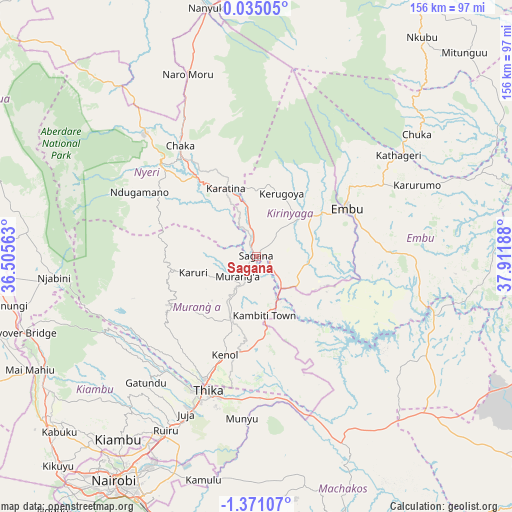
Sagana GPS coordinates[2]
0° 40' 5.016" South, 37° 12' 31.5" East
| Map corner | latitude | longitude |
|---|---|---|
| Upper-left | 0.03505°, | 36.50563° |
| Center: | -0.66806°, | 37.20875° |
| Lower-right: | -1.37107°, | 37.91188° |
| Map W x H: | 156.3×156.3 km | = 97.1×97.1mi |
| max Lat: | 3.93726° ⇑55.3% North |
| Sagana: | -0.66806° |
| min Lat: | ⇓44.7% South -4.64756° |
| min Long | Sagana | max Long |
| 33.97248° | 37.20875° | 41.85688° |
| W 67.5%⇐ | ⇒32.5% E |
Elevation
Elevation of Sagana is 1201 m = 3940 ft, and this is 145.7 m = 478 ft below average elevation for this country.
| Max E: |
2514 m = 8248 ft | 67.5% |
| Avg. | 1346.7 m = 4418 ft | |
| Sagana | 1201 m = 3940 ft | |
Min E: |
7 m = 23 ft | 32.5% |
See also: Kenya elevation on elevation.city.
Geographical zone
Sagana is located in South Torrid zone (between Equator and Tropic of Capricorn). Distance of Equator is 74.3 km =46.2 mi to North.| Distance of | km | miles | from Sagana |
|---|---|---|---|
| Equator | 74.3 | 46.2 | to North |
| Tropic Capricorn | 2531.6 | 1573.1 | to South |
| Antarctic Circle | 7326.9 | 4552.7 | to South |
| South Pole | 9932.8 | 6172 | to South |


Nearby cities:
15 places around Sagana: (largest is in red/bold)
• Chuka
61.2 km =38 mi,  52°
52°
• Embu
31.1 km =19.3 mi,  62°
62°
• Kandara
34.3 km =21.3 mi,  221°
221°
• Kangema
27.2 km =16.9 mi,  265°
265°
• Kangundo
72.3 km =44.9 mi,  167°
167°
• Karuri
4.5 km =2.8 mi, 218°
• Kerugoya
20.4 km =12.7 mi,  22°
22°
• Kiambu
69.7 km =43.3 mi, 216°
• Maragua
16.5 km =10.3 mi,  210°
210°
• Murang’a
8.6 km =5.3 mi,  226°
226°
• Nanyuki
76.5 km =47.5 mi,  348°
348°
• Naro Moru
60 km =37.3 mi,  339°
339°
• Nyeri
40 km =24.9 mi,  313°
313°
• Othaya
33.6 km =20.9 mi,  293°
293°
• Thika
43.5 km =27 mi,  200°
200°
Sources, notices
• [Note1] Compared only with cities in Kenya existing in our database
• [Src1] Map data: © OpenStreetMap contributors (CC-BY-SA)
• [Src2] Other city data from geonames.org with taken over terms of usage.
• [Src3] Geographical zone / Annual Mean Temperature by Robert A. Rohde @ Wikipedia
