Chuka geodata
Chuka (Tharaka - Nithi) is a seat of a second-order administrative division; located in Kenya in Africa/Nairobi (GMT+3) time zone. With population of 9,347 people, there are 70 cities with bigger population in this country. Compared to other cities in Kenya, 54.4% of cities are located further ↓South; 74.6% of cities are located further ←West and 50.9% of cities have higher elevation than Chuka. Note1


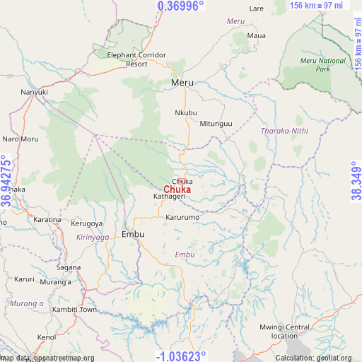
Chuka GPS coordinates[2]
0° 19' 59.376" South, 37° 38' 45.132" East
| Map corner | latitude | longitude |
|---|---|---|
| Upper-left | 0.36996°, | 36.94275° |
| Center: | -0.33316°, | 37.64587° |
| Lower-right: | -1.03623°, | 38.349° |
| Map W x H: | 156.4×156.4 km | = 97.2×97.2mi |
| max Lat: | 3.93726° ⇑45.6% North |
| Chuka: | -0.33316° |
| min Lat: | ⇓54.4% South -4.64756° |
| min Long | Chuka | max Long |
| 33.97248° | 37.64587° | 41.85688° |
| W 74.6%⇐ | ⇒25.4% E |
Elevation
Elevation of Chuka is 1452 m = 4764 ft, and this is 105.3 m = 345 ft above average elevation for this country.
| Max E: |
2514 m = 8248 ft | 50.9% |
| Chuka | 1452 m 4764 ft | |
| Avg. | 1346.7 m = 4418 ft | |
Min E: |
7 m = 23 ft | 49.1% |
See also: Kenya elevation on elevation.city.
Geographical zone
Chuka is located in South Torrid zone (between Equator and Tropic of Capricorn). Distance of Equator is 37 km =23 mi to North.| Distance of | km | miles | from Chuka |
|---|---|---|---|
| Equator | 37 | 23 | to North |
| Tropic Capricorn | 2568.9 | 1596.2 | to South |
| Antarctic Circle | 7364.1 | 4575.8 | to South |
| South Pole | 9970 | 6195.1 | to South |


Nearby cities:
15 places around Chuka: (largest is in red/bold)
• Embu
31.1 km =19.3 mi,  222°
222°
• Isiolo
76.8 km =47.7 mi,  354°
354°
• Karuri
65.6 km =40.8 mi,  231°
231°
• Kathwana
24.8 km =15.4 mi,  89°
89°
• Kerugoya
44.6 km =27.7 mi,  245°
245°
• Maragua
76.8 km =47.7 mi, 227°
• Maua
71 km =44.1 mi,  27°
27°
• Meru
42.2 km =26.2 mi,  1°
1°
• Murang’a
69.8 km =43.4 mi, 231°
• Mwingi
81.3 km =50.5 mi,  145°
145°
• Nanyuki
73.9 km =45.9 mi,  300°
300°
• Naro Moru
72.3 km =44.9 mi,  285°
285°
• Nyeri
78.2 km =48.6 mi,  262°
262°
• Othaya
82.9 km =51.5 mi, 253°
• Sagana
61.2 km =38 mi, 232°
Sources, notices
• [Note1] Compared only with cities in Kenya existing in our database
• [Src1] Map data: © OpenStreetMap contributors (CC-BY-SA)
• [Src2] Other city data from geonames.org with taken over terms of usage.
• [Src3] Geographical zone / Annual Mean Temperature by Robert A. Rohde @ Wikipedia
