Maua geodata
Maua (Meru) is a populated place; located in Kenya in Africa/Nairobi (GMT+3) time zone. With population of 10,804 people, there are 63 cities with bigger population in this country. Compared to other cities in Kenya, 75.4% of cities are located further ↓South; 78.1% of cities are located further ←West and 64% of cities have lower elevation than Maua. Note1


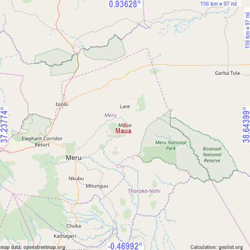
Maua GPS coordinates[2]
0° 13' 59.52" North, 37° 56' 27.096" East
| Map corner | latitude | longitude |
|---|---|---|
| Upper-left | 0.93628°, | 37.23774° |
| Center: | 0.2332°, | 37.94086° |
| Lower-right: | -0.46992°, | 38.64399° |
| Map W x H: | 156.4×156.4 km | = 97.2×97.2mi |
| max Lat: | 3.93726° ⇑24.6% North |
| Maua: | 0.2332° |
| min Lat: | ⇓75.4% South -4.64756° |
| min Long | Maua | max Long |
| 33.97248° | 37.94086° | 41.85688° |
| W 78.1%⇐ | ⇒21.9% E |
Elevation
Elevation of Maua is 1655 m = 5430 ft, and this is 308.3 m = 1011 ft above average elevation for this country.
| Max E: |
2514 m = 8248 ft | 36% |
| Maua | 1655 m 5430 ft | |
| Avg. | 1346.7 m = 4418 ft | |
Min E: |
7 m = 23 ft | 64% |
See also: Kenya elevation on elevation.city.
Geographical zone
Maua is located in North Torrid zone (between Equator and Tropic of Cancer). Distance of Equator is 25.9 km =16.1 mi to South.| Distance of | km | miles | from Maua |
|---|---|---|---|
| North Pole | 9981.1 | 6202 | to North |
| Arctic Circle | 7375.2 | 4582.7 | to North |
| Tropic Cancer | 2580 | 1603.1 | to North |
| Equator | 25.9 | 16.1 | to South |


Nearby cities:
15 places around Maua: (largest is in red/bold)
• Chuka
71 km =44.1 mi,  207°
207°
• Embu
101.4 km =63 mi, 212°
• Isiolo
42.1 km =26.2 mi,  288°
288°
• Karuri
133.6 km =83 mi,  219°
219°
• Kathwana
63.3 km =39.3 mi,  187°
187°
• Kerugoya
109.6 km =68.1 mi, 222°
• Maragua
145.5 km =90.4 mi, 218°
• Meru
37.9 km =23.5 mi,  236°
236°
• Murang’a
137.6 km =85.5 mi, 219°
• Mwingi
130.7 km =81.2 mi,  174°
174°
• Nanyuki
99.6 km =61.9 mi,  255°
255°
• Naro Moru
111.7 km =69.4 mi,  246°
246°
• Nyeri
132.2 km =82.1 mi, 236°
• Othaya
141.8 km =88.1 mi,  232°
232°
• Sagana
129.1 km =80.2 mi, 219°
Sources, notices
• [Note1] Compared only with cities in Kenya existing in our database
• [Src1] Map data: © OpenStreetMap contributors (CC-BY-SA)
• [Src2] Other city data from geonames.org with taken over terms of usage.
• [Src3] Geographical zone / Annual Mean Temperature by Robert A. Rohde @ Wikipedia
