Meru geodata
Meru is a seat of a first-order administrative division; located in Kenya in Africa/Nairobi (GMT+3) time zone. With population of 47,226 people, there are 15 cities with bigger population in this country. Compared to other cities in Kenya, 66.7% of cities are located further ↓South; 75.4% of cities are located further ←West and 58.8% of cities have lower elevation than Meru. Note1


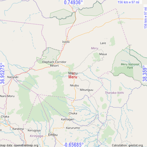
Meru GPS coordinates[2]
0° 2' 46.536" North, 37° 39' 21.132" East
| Map corner | latitude | longitude |
|---|---|---|
| Upper-left | 0.74936°, | 36.95275° |
| Center: | 0.04626°, | 37.65587° |
| Lower-right: | -0.65685°, | 38.359° |
| Map W x H: | 156.4×156.4 km | = 97.2×97.2mi |
| max Lat: | 3.93726° ⇑33.3% North |
| Meru: | 0.04626° |
| min Lat: | ⇓66.7% South -4.64756° |
| min Long | Meru | max Long |
| 33.97248° | 37.65587° | 41.85688° |
| W 75.4%⇐ | ⇒24.6% E |
Elevation
Elevation of Meru is 1579 m = 5180 ft, and this is 232.3 m = 762 ft above average elevation for this country.
| Max E: |
2514 m = 8248 ft | 41.2% |
| Meru | 1579 m 5180 ft | |
| Avg. | 1346.7 m = 4418 ft | |
Min E: |
7 m = 23 ft | 58.8% |
See also: Meru elevation on elevation.city.
Geographical zone
Meru is located in North Torrid zone (between Equator and Tropic of Cancer). Distance of Equator is 5.1 km =3.2 mi to South.| Distance of | km | miles | from Meru |
|---|---|---|---|
| North Pole | 10001.9 | 6214.9 | to North |
| Arctic Circle | 7396 | 4595.7 | to North |
| Tropic Cancer | 2600.8 | 1616.1 | to North |
| Equator | 5.1 | 3.2 | to South |


Nearby cities:
15 places around Meru: (largest is in red/bold)
• Chuka
42.2 km =26.2 mi,  181°
181°
• Embu
68.8 km =42.8 mi,  198°
198°
• Isiolo
35.3 km =21.9 mi,  346°
346°
• Kangema
111.9 km =69.5 mi,  223°
223°
• Karuri
98.2 km =61 mi,  212°
212°
• Kathwana
48.2 km =30 mi,  150°
150°
• Kerugoya
73.6 km =45.7 mi, 214°
• Maragua
110.2 km =68.5 mi, 211°
• Maua
37.9 km =23.5 mi,  56°
56°
• Murang’a
102 km =63.4 mi, 213°
• Nanyuki
64.9 km =40.3 mi,  266°
266°
• Naro Moru
74.7 km =46.4 mi,  251°
251°
• Nyeri
94.3 km =58.6 mi,  236°
236°
• Othaya
104.1 km =64.7 mi,  230°
230°
• Sagana
93.7 km =58.2 mi, 212°
Sources, notices
• [Note1] Compared only with cities in Kenya existing in our database
• [Src1] Map data: © OpenStreetMap contributors (CC-BY-SA)
• [Src2] Other city data from geonames.org with taken over terms of usage.
• [Src3] Geographical zone / Annual Mean Temperature by Robert A. Rohde @ Wikipedia
