Isiolo geodata
Isiolo is a seat of a first-order administrative division; located in Kenya in Africa/Nairobi (GMT+3) time zone. With population of 33,207 people, there are 31 cities with bigger population in this country. Compared to other cities in Kenya, 80.7% of cities are located further ↓South; 71.9% of cities are located further ←West and 76.3% of cities have higher elevation than Isiolo. Note1


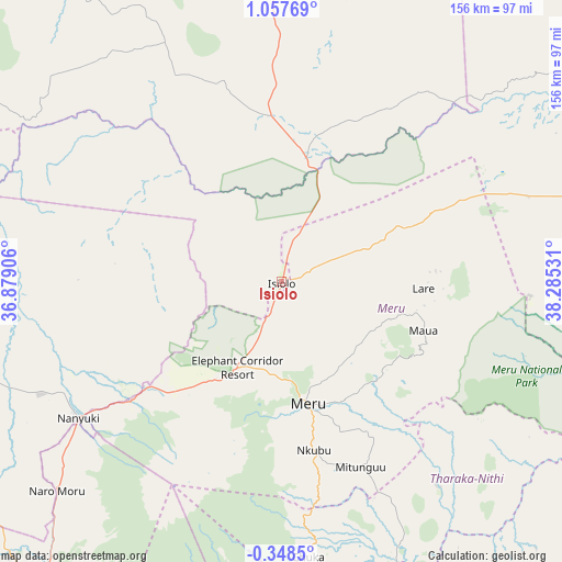
Isiolo GPS coordinates[2]
0° 21' 16.632" North, 37° 34' 55.848" East
| Map corner | latitude | longitude |
|---|---|---|
| Upper-left | 1.05769°, | 36.87906° |
| Center: | 0.35462°, | 37.58218° |
| Lower-right: | -0.3485°, | 38.28531° |
| Map W x H: | 156.4×156.4 km | = 97.2×97.2mi |
| max Lat: | 3.93726° ⇑19.3% North |
| Isiolo: | 0.35462° |
| min Lat: | ⇓80.7% South -4.64756° |
| min Long | Isiolo | max Long |
| 33.97248° | 37.58218° | 41.85688° |
| W 71.9%⇐ | ⇒28.1% E |
Elevation
Elevation of Isiolo is 1095 m = 3593 ft, and this is 251.7 m = 826 ft below average elevation for this country.
| Max E: |
2514 m = 8248 ft | 76.3% |
| Avg. | 1346.7 m = 4418 ft | |
| Isiolo | 1095 m = 3593 ft | |
Min E: |
7 m = 23 ft | 23.7% |
See also: Kenya elevation on elevation.city.
Geographical zone
Isiolo is located in North Torrid zone (between Equator and Tropic of Cancer). Distance of Equator is 39.4 km =24.5 mi to South.| Distance of | km | miles | from Isiolo |
|---|---|---|---|
| North Pole | 9967.6 | 6193.6 | to North |
| Arctic Circle | 7361.7 | 4574.3 | to North |
| Tropic Cancer | 2566.5 | 1594.7 | to North |
| Equator | 39.4 | 24.5 | to South |


Nearby cities:
15 places around Isiolo: (largest is in red/bold)
• Chuka
76.8 km =47.7 mi,  174°
174°
• Embu
100.4 km =62.4 mi,  187°
187°
• Karuri
125.4 km =77.9 mi,  200°
200°
• Kathwana
82.7 km =51.4 mi,  157°
157°
• Kerugoya
100.7 km =62.6 mi, 199°
• Maralal
128.3 km =79.7 mi,  310°
310°
• Maua
42.1 km =26.2 mi,  108°
108°
• Meru
35.3 km =21.9 mi, 166°
• Murang’a
128.8 km =80 mi, 201°
• Nanyuki
68.5 km =42.6 mi,  235°
235°
• Naro Moru
85.2 km =52.9 mi,  227°
227°
• Nyeri
111.4 km =69.2 mi,  219°
219°
• Othaya
123.6 km =76.8 mi, 215°
• Rumuruti
116.5 km =72.4 mi,  265°
265°
• Sagana
121.1 km =75.2 mi, 200°
Sources, notices
• [Note1] Compared only with cities in Kenya existing in our database
• [Src1] Map data: © OpenStreetMap contributors (CC-BY-SA)
• [Src2] Other city data from geonames.org with taken over terms of usage.
• [Src3] Geographical zone / Annual Mean Temperature by Robert A. Rohde @ Wikipedia
