Embu geodata
Embu is a seat of a first-order administrative division; located in Kenya in Africa/Nairobi (GMT+3) time zone. With population of 34,922 people, there are 29 cities with bigger population in this country. Compared to other cities in Kenya, 51.8% of cities are located further ↑North; 71.1% of cities are located further ←West and 60.5% of cities have higher elevation than Embu. Note1


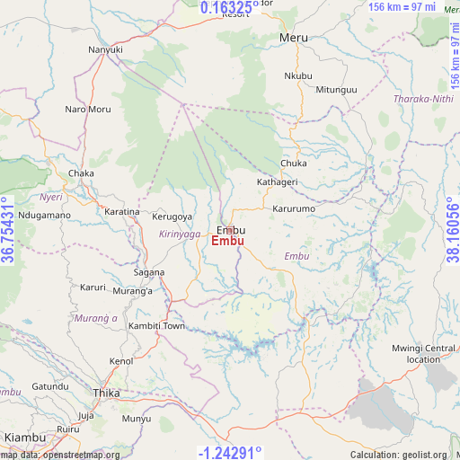
Embu GPS coordinates[2]
0° 32' 23.532" South, 37° 27' 26.748" East
| Map corner | latitude | longitude |
|---|---|---|
| Upper-left | 0.16325°, | 36.75431° |
| Center: | -0.53987°, | 37.45743° |
| Lower-right: | -1.24291°, | 38.16056° |
| Map W x H: | 156.4×156.4 km | = 97.2×97.2mi |
| max Lat: | 3.93726° ⇑51.8% North |
| Embu: | -0.53987° |
| min Lat: | ⇓48.2% South -4.64756° |
| min Long | Embu | max Long |
| 33.97248° | 37.45743° | 41.85688° |
| W 71.1%⇐ | ⇒28.9% E |
Elevation
Elevation of Embu is 1294 m = 4245 ft, and this is 52.7 m = 173 ft below average elevation for this country.
| Max E: |
2514 m = 8248 ft | 60.5% |
| Avg. | 1346.7 m = 4418 ft | |
| Embu | 1294 m = 4245 ft | |
Min E: |
7 m = 23 ft | 39.5% |
See also: Kenya elevation on elevation.city.
Geographical zone
Embu is located in South Torrid zone (between Equator and Tropic of Capricorn). Distance of Equator is 60 km =37.3 mi to North.| Distance of | km | miles | from Embu |
|---|---|---|---|
| Equator | 60 | 37.3 | to North |
| Tropic Capricorn | 2545.9 | 1581.9 | to South |
| Antarctic Circle | 7341.1 | 4561.5 | to South |
| South Pole | 9947 | 6180.8 | to South |


Nearby cities:
15 places around Embu: (largest is in red/bold)
• Chuka
31.1 km =19.3 mi,  42°
42°
• Kandara
64.3 km =40 mi,  231°
231°
• Kangema
57.1 km =35.5 mi,  253°
253°
• Karuri
35.3 km =21.9 mi,  239°
239°
• Kathwana
51.3 km =31.9 mi,  63°
63°
• Kerugoya
20.2 km =12.6 mi,  283°
283°
• Maragua
46 km =28.6 mi, 231°
• Meru
68.8 km =42.8 mi,  18°
18°
• Murang’a
39.4 km =24.5 mi, 239°
• Nanyuki
74.2 km =46.1 mi,  324°
324°
• Naro Moru
64.3 km =40 mi,  310°
310°
• Nyeri
58.2 km =36.2 mi, 283°
• Othaya
58.4 km =36.3 mi,  269°
269°
• Sagana
31.1 km =19.3 mi, 242°
• Thika
69.8 km =43.4 mi,  218°
218°
Sources, notices
• [Note1] Compared only with cities in Kenya existing in our database
• [Src1] Map data: © OpenStreetMap contributors (CC-BY-SA)
• [Src2] Other city data from geonames.org with taken over terms of usage.
• [Src3] Geographical zone / Annual Mean Temperature by Robert A. Rohde @ Wikipedia
