Kapsowar geodata
Kapsowar (Elegeyo-Marakwet) is a populated place; located in Kenya in Africa/Nairobi (GMT+3) time zone. With population of 9,152 people, there are 71 cities with bigger population in this country. Compared to other cities in Kenya, 92.1% of cities are located further ↓South; 64% of cities are located further →East and 92.1% of cities have lower elevation than Kapsowar. Note1


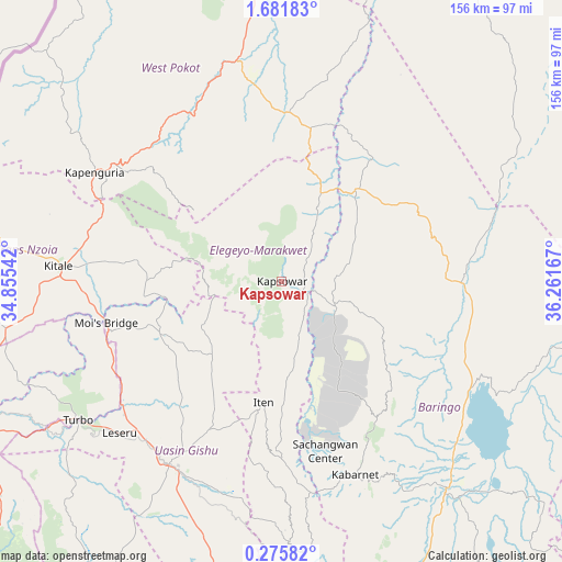
Kapsowar GPS coordinates[2]
0° 58' 44.04" North, 35° 33' 30.744" East
| Map corner | latitude | longitude |
|---|---|---|
| Upper-left | 1.68183°, | 34.85542° |
| Center: | 0.9789°, | 35.55854° |
| Lower-right: | 0.27582°, | 36.26167° |
| Map W x H: | 156.3×156.3 km | = 97.1×97.1mi |
| max Lat: | 3.93726° ⇑7.9% North |
| Kapsowar: | 0.9789° |
| min Lat: | ⇓92.1% South -4.64756° |
| min Long | Kapsowar | max Long |
| 33.97248° | 35.55854° | 41.85688° |
| W 36%⇐ | ⇒64% E |
Elevation
Elevation of Kapsowar is 2058 m = 6752 ft, and this is 711.3 m = 2334 ft above average elevation for this country.
| Max E: |
2514 m = 8248 ft | 7.9% |
| Kapsowar | 2058 m 6752 ft | |
| Avg. | 1346.7 m = 4418 ft | |
Min E: |
7 m = 23 ft | 92.1% |
See also: Kenya elevation on elevation.city.
Geographical zone
Kapsowar is located in North Torrid zone (between Equator and Tropic of Cancer). Distance of Equator is 108.8 km =67.6 mi to South.| Distance of | km | miles | from Kapsowar |
|---|---|---|---|
| North Pole | 9898.2 | 6150.5 | to North |
| Arctic Circle | 7292.3 | 4531.2 | to North |
| Tropic Cancer | 2497.1 | 1551.6 | to North |
| Equator | 108.8 | 67.6 | to South |


Nearby cities:
15 places around Kapsowar: (largest is in red/bold)
• Baringo
72.8 km =45.2 mi,  141°
141°
• Bungoma
117 km =72.7 mi,  247°
247°
• Bungoma
120.2 km =74.7 mi, 247°
• Chepareria
53.6 km =33.3 mi,  312°
312°
• Eldama Ravine
104.8 km =65.1 mi,  169°
169°
• Eldoret
60.2 km =37.4 mi,  212°
212°
• Iten
34.8 km =21.6 mi,  189°
189°
• Kabarnet
57.9 km =36 mi,  159°
159°
• Kakamega
118.3 km =73.5 mi,  229°
229°
• Kapenguria
57.5 km =35.7 mi,  300°
300°
• Kapsabet
99.8 km =62 mi, 210°
• Kitale
61.5 km =38.2 mi,  273°
273°
• Londiani
127.3 km =79.1 mi,  178°
178°
• Nandi Hills
105.8 km =65.7 mi,  203°
203°
• Webuye
97.1 km =60.3 mi,  244°
244°
Sources, notices
• [Note1] Compared only with cities in Kenya existing in our database
• [Src1] Map data: © OpenStreetMap contributors (CC-BY-SA)
• [Src2] Other city data from geonames.org with taken over terms of usage.
• [Src3] Geographical zone / Annual Mean Temperature by Robert A. Rohde @ Wikipedia
