Bazar-Korgon geodata
Bazar-Korgon (Jalal-Abad) is a seat of a second-order administrative division; located in Kyrgyzstan in Asia/Bishkek (GMT+6) time zone. With population of 27,704 people, there are 11 cities with bigger population in this country. Compared to other cities in Kyrgyzstan, 52.4% of cities are located further ↓South; 57.1% of cities are located further ←West and 91.7% of cities have higher elevation than Bazar-Korgon. Note1


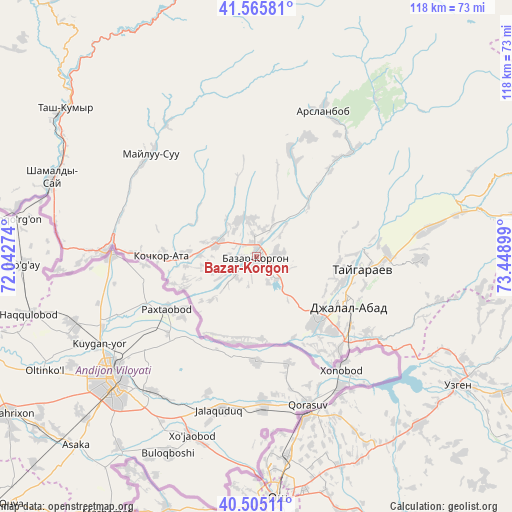
Bazar-Korgon GPS coordinates[2]
41° 2' 15.36" North, 72° 44' 45.096" East
| Map corner | latitude | longitude |
|---|---|---|
| Upper-left | 41.56581°, | 72.04274° |
| Center: | 41.0376°, | 72.74586° |
| Lower-right: | 40.50511°, | 73.44899° |
| Map W x H: | 117.9×117.9 km | = 73.3×73.3mi |
| max Lat: | 42.89106° ⇑47.6% North |
| Bazar-Korgon: | 41.0376° |
| min Lat: | ⇓52.4% South 39.55274° |
| min Long | Bazar-Korgon | max Long |
| 69.3716° | 72.74586° | 78.52702° |
| W 57.1%⇐ | ⇒42.9% E |
Elevation
Elevation of Bazar-Korgon is 729 m = 2392 ft, and this is 472.4 m = 1550 ft below average elevation for this country.
| Max E: |
2638 m = 8655 ft | 91.7% |
| Avg. | 1201.4 m = 3942 ft | |
| Bazar-Korgon | 729 m = 2392 ft | |
Min E: |
504 m = 1654 ft | 8.3% |
See also: Kyrgyzstan elevation on elevation.city.
Geographical zone
Bazar-Korgon is located in North temperate zone (between Tropic of Cancer and the Arctic Circle). Distance of this Northern Tropic circle is 1957 km =1216 mi to South.| Distance of | km | miles | from Bazar-Korgon |
|---|---|---|---|
| North Pole | 5444.1 | 3382.8 | to North |
| Arctic Circle | 2838.2 | 1763.6 | to North |
| Tropic Cancer | 1957 | 1216 | to South |
| Equator | 4563 | 2835.3 | to South |


Nearby cities:
15 places around Bazar-Korgon: (largest is in red/bold)
• Aravan
61.6 km =38.3 mi,  199°
199°
• Jalal-Abad
24.3 km =15.1 mi,  118°
118°
• Kara Suu
38.4 km =23.9 mi,  164°
164°
• Kara-Kulja
84.3 km =52.4 mi, 122°
• Karavan
95.1 km =59.1 mi,  209°
209°
• Kerben
96.9 km =60.2 mi,  301°
301°
• Kochkor-Ata
22 km =13.7 mi,  269°
269°
• Massy
9.8 km =6.1 mi,  284°
284°
• Nookat
86.5 km =53.7 mi,  187°
187°
• Osh
56.8 km =35.3 mi,  175°
175°
• Suzak
20.5 km =12.7 mi,  139°
139°
• Tash-Kumyr
56 km =34.8 mi,  307°
307°
• Toktogul
94.5 km =58.7 mi,  9°
9°
• Uzgen
55.3 km =34.4 mi, 122°
• Üch-Terek
89 km =55.3 mi,  25°
25°
Sources, notices
• [Note1] Compared only with cities in Kyrgyzstan existing in our database
• [Src1] Map data: © OpenStreetMap contributors (CC-BY-SA)
• [Src2] Other city data from geonames.org with taken over terms of usage.
• [Src3] Geographical zone / Annual Mean Temperature by Robert A. Rohde @ Wikipedia
