Massy geodata
Massy (Jalal-Abad) is a seat of a second-order administrative division; located in Kyrgyzstan in Asia/Bishkek (GMT+6) time zone. In our database, there are 37 cities with bigger population. Compared to other cities in Kyrgyzstan, 53.6% of cities are located further ↓South; 54.8% of cities are located further ←West and 95.2% of cities have higher elevation than Massy. Note1


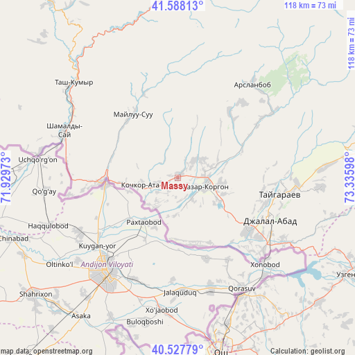
Massy GPS coordinates[2]
41° 3' 36.36" North, 72° 37' 58.26" East
| Map corner | latitude | longitude |
|---|---|---|
| Upper-left | 41.58813°, | 71.92973° |
| Center: | 41.0601°, | 72.63285° |
| Lower-right: | 40.52779°, | 73.33598° |
| Map W x H: | 117.9×117.9 km | = 73.3×73.3mi |
| max Lat: | 42.89106° ⇑46.4% North |
| Massy: | 41.0601° |
| min Lat: | ⇓53.6% South 39.55274° |
| min Long | Massy | max Long |
| 69.3716° | 72.63285° | 78.52702° |
| W 54.8%⇐ | ⇒45.2% E |
Elevation
Elevation of Massy is 690 m = 2264 ft, and this is 511.4 m = 1678 ft below average elevation for this country.
| Max E: |
2638 m = 8655 ft | 95.2% |
| Avg. | 1201.4 m = 3942 ft | |
| Massy | 690 m = 2264 ft | |
Min E: |
504 m = 1654 ft | 4.8% |
See also: Kyrgyzstan elevation on elevation.city.
Geographical zone
Massy is located in North temperate zone (between Tropic of Cancer and the Arctic Circle). Distance of this Northern Tropic circle is 1959.5 km =1217.6 mi to South.| Distance of | km | miles | from Massy |
|---|---|---|---|
| North Pole | 5441.6 | 3381.3 | to North |
| Arctic Circle | 2835.7 | 1762 | to North |
| Tropic Cancer | 1959.5 | 1217.6 | to South |
| Equator | 4565.5 | 2836.9 | to South |


Nearby cities:
15 places around Massy: (largest is in red/bold)
• Aravan
61.5 km =38.2 mi,  190°
190°
• Bazar-Korgon
9.8 km =6.1 mi,  104°
104°
• Jalal-Abad
33.9 km =21.1 mi,  114°
114°
• Kara Suu
44.1 km =27.4 mi,  153°
153°
• Kara-Kulja
93.7 km =58.2 mi,  120°
120°
• Karavan
93 km =57.8 mi,  203°
203°
• Kerben
87.6 km =54.4 mi,  303°
303°
• Kochkor-Ata
12.8 km =8 mi,  258°
258°
• Nookat
88.3 km =54.9 mi,  180°
180°
• Osh
60.8 km =37.8 mi,  166°
166°
• Suzak
29.1 km =18.1 mi,  128°
128°
• Tash-Kumyr
47.1 km =29.3 mi,  312°
312°
• Toktogul
94.1 km =58.5 mi,  15°
15°
• Uzgen
64.7 km =40.2 mi, 119°
• Üch-Terek
91.3 km =56.7 mi,  31°
31°
Sources, notices
• [Note1] Compared only with cities in Kyrgyzstan existing in our database
• [Src1] Map data: © OpenStreetMap contributors (CC-BY-SA)
• [Src2] Other city data from geonames.org with taken over terms of usage.
• [Src3] Geographical zone / Annual Mean Temperature by Robert A. Rohde @ Wikipedia
