Kara-Kulja geodata
Kara-Kulja (Osh) is a seat of a second-order administrative division; located in Kyrgyzstan in Asia/Bishkek (GMT+6) time zone. In our database, there are 37 cities with bigger population. Compared to other cities in Kyrgyzstan, 54.8% of cities are located further ↑North; 67.9% of cities are located further ←West and 72.6% of cities have lower elevation than Kara-Kulja. Note1


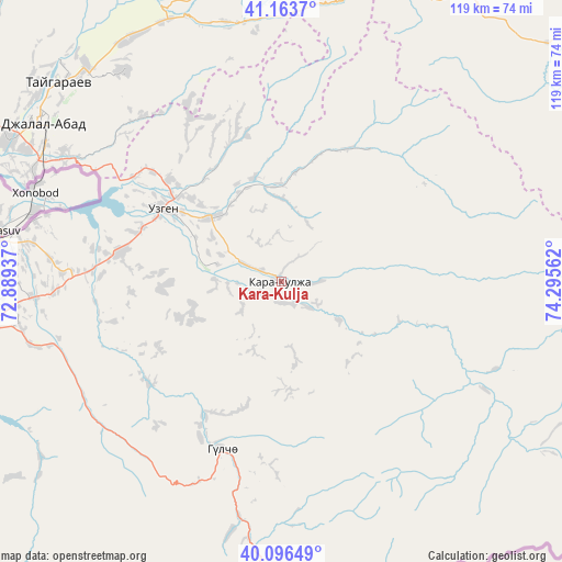
Kara-Kulja GPS coordinates[2]
40° 37' 56.028" North, 73° 35' 32.964" East
| Map corner | latitude | longitude |
|---|---|---|
| Upper-left | 41.1637°, | 72.88937° |
| Center: | 40.63223°, | 73.59249° |
| Lower-right: | 40.09649°, | 74.29562° |
| Map W x H: | 118.7×118.7 km | = 73.8×73.8mi |
| max Lat: | 42.89106° ⇑54.8% North |
| Kara-Kulja: | 40.63223° |
| min Lat: | ⇓45.2% South 39.55274° |
| min Long | Kara-Kulja | max Long |
| 69.3716° | 73.59249° | 78.52702° |
| W 67.9%⇐ | ⇒32.1% E |
Elevation
Elevation of Kara-Kulja is 1384 m = 4541 ft, and this is 182.6 m = 599 ft above average elevation for this country.
| Max E: |
2638 m = 8655 ft | 27.4% |
| Kara-Kulja | 1384 m 4541 ft | |
| Avg. | 1201.4 m = 3942 ft | |
Min E: |
504 m = 1654 ft | 72.6% |
See also: Kyrgyzstan elevation on elevation.city.
Geographical zone
Kara-Kulja is located in North temperate zone (between Tropic of Cancer and the Arctic Circle). Distance of this Northern Tropic circle is 1912 km =1188.1 mi to South.| Distance of | km | miles | from Kara-Kulja |
|---|---|---|---|
| North Pole | 5489.2 | 3410.8 | to North |
| Arctic Circle | 2883.3 | 1791.6 | to North |
| Tropic Cancer | 1912 | 1188.1 | to South |
| Equator | 4517.9 | 2807.3 | to South |


Nearby cities:
15 places around Kara-Kulja: (largest is in red/bold)
• Aravan
93.2 km =57.9 mi,  262°
262°
• Bazar-Korgon
84.3 km =52.4 mi,  302°
302°
• Gul’cha
37.6 km =23.4 mi,  199°
199°
• Jalal-Abad
60.1 km =37.3 mi, 303°
• Kara Suu
61.7 km =38.3 mi,  277°
277°
• Karavan
124.7 km =77.5 mi,  252°
252°
• Kazarman
93.3 km =58 mi,  23°
23°
• Kochkor-Ata
103.6 km =64.4 mi, 295°
• Kyzyl-Kyya
130.8 km =81.3 mi, 251°
• Massy
93.7 km =58.2 mi, 300°
• Nookat
91.9 km =57.1 mi,  243°
243°
• Osh
68 km =42.3 mi, 260°
• Suzak
65 km =40.4 mi, 297°
• Uzgen
29 km =18 mi, 301°
• Üch-Terek
129.9 km =80.7 mi,  345°
345°
Sources, notices
• [Note1] Compared only with cities in Kyrgyzstan existing in our database
• [Src1] Map data: © OpenStreetMap contributors (CC-BY-SA)
• [Src2] Other city data from geonames.org with taken over terms of usage.
• [Src3] Geographical zone / Annual Mean Temperature by Robert A. Rohde @ Wikipedia
