Kara-Balta geodata
Kara-Balta (Chüy) is a seat of a second-order administrative division; located in Kyrgyzstan in Asia/Bishkek (GMT+6) time zone. With population of 62,796 people, there are 5 cities with bigger population in this country. Compared to other cities in Kyrgyzstan, 89.3% of cities are located further ↓South; 70.2% of cities are located further ←West and 76.2% of cities have higher elevation than Kara-Balta. Note1


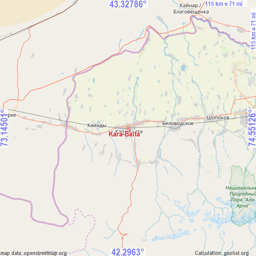
Kara-Balta GPS coordinates[2]
42° 48' 51.228" North, 73° 50' 53.268" East
| Map corner | latitude | longitude |
|---|---|---|
| Upper-left | 43.32786°, | 73.14501° |
| Center: | 42.81423°, | 73.84813° |
| Lower-right: | 42.2963°, | 74.55126° |
| Map W x H: | 114.7×114.7 km | = 71.3×71.3mi |
| max Lat: | 42.89106° ⇑10.7% North |
| Kara-Balta: | 42.81423° |
| min Lat: | ⇓89.3% South 39.55274° |
| min Long | Kara-Balta | max Long |
| 69.3716° | 73.84813° | 78.52702° |
| W 70.2%⇐ | ⇒29.8% E |
Elevation
Elevation of Kara-Balta is 789 m = 2589 ft, and this is 412.4 m = 1353 ft below average elevation for this country.
| Max E: |
2638 m = 8655 ft | 76.2% |
| Avg. | 1201.4 m = 3942 ft | |
| Kara-Balta | 789 m = 2589 ft | |
Min E: |
504 m = 1654 ft | 23.8% |
See also: Kara-Balta elevation on elevation.city.
Geographical zone
Kara-Balta is located in North temperate zone (between Tropic of Cancer and the Arctic Circle). Distance of this Northern Tropic circle is 2154.6 km =1338.8 mi to South.| Distance of | km | miles | from Kara-Balta |
|---|---|---|---|
| North Pole | 5246.6 | 3260.1 | to North |
| Arctic Circle | 2640.7 | 1640.9 | to North |
| Tropic Cancer | 2154.6 | 1338.8 | to South |
| Equator | 4760.5 | 2958 | to South |


Nearby cities:
15 places around Kara-Balta: (largest is in red/bold)
• Belovodskoye
21.3 km =13.2 mi,  85°
85°
• Bishkek
60.8 km =37.8 mi,  84°
84°
• Chayek
112.9 km =70.2 mi,  150°
150°
• Chuy
117 km =72.7 mi, 89°
• Ivanovka
101.2 km =62.9 mi, 85°
• Kaindy
14.1 km =8.8 mi,  274°
274°
• Kant
82.2 km =51.1 mi, 84°
• Lebedinovka
68.1 km =42.3 mi, 83°
• Sokuluk
37.3 km =23.2 mi, 83°
• Sosnovka
20.1 km =12.5 mi,  168°
168°
• Talas
110.1 km =68.4 mi,  242°
242°
• Talas
135.2 km =84 mi,  256°
256°
• Tokmok
118.6 km =73.7 mi, 88°
• Toktogul
128.3 km =79.7 mi,  215°
215°
• Üch-Terek
128.5 km =79.8 mi,  204°
204°
Sources, notices
• [Note1] Compared only with cities in Kyrgyzstan existing in our database
• [Src1] Map data: © OpenStreetMap contributors (CC-BY-SA)
• [Src2] Other city data from geonames.org with taken over terms of usage.
• [Src3] Geographical zone / Annual Mean Temperature by Robert A. Rohde @ Wikipedia
