Talas geodata
Talas is a seat of a second-order administrative division; located in Kyrgyzstan in Asia/Bishkek (GMT+6) time zone. In our database, there are 37 cities with bigger population. Compared to other cities in Kyrgyzstan, 73.8% of cities are located further ↓South; 56% of cities are located further ←West and 100% of cities have lower elevation than Talas. Note1


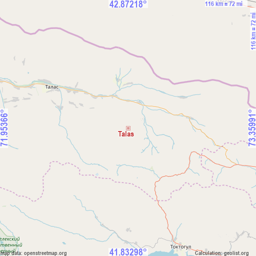
Talas GPS coordinates[2]
42° 21' 17.028" North, 72° 39' 24.408" East
| Map corner | latitude | longitude |
|---|---|---|
| Upper-left | 42.87218°, | 71.95366° |
| Center: | 42.35473°, | 72.65678° |
| Lower-right: | 41.83298°, | 73.35991° |
| Map W x H: | 115.5×115.5 km | = 71.8×71.8mi |
| max Lat: | 42.89106° ⇑26.2% North |
| Talas: | 42.35473° |
| min Lat: | ⇓73.8% South 39.55274° |
| min Long | Talas | max Long |
| 69.3716° | 72.65678° | 78.52702° |
| W 56%⇐ | ⇒44% E |
Elevation
Elevation of Talas is 2638 m = 8655 ft, and this is 1436.6 m = 4713 ft above average elevation for this country.
| Max E: |
2638 m = 8655 ft | 0% |
| Talas | 2638 m 8655 ft | |
| Avg. | 1201.4 m = 3942 ft | |
Min E: |
504 m = 1654 ft | 100% |
See also: Kyrgyzstan elevation on elevation.city.
Geographical zone
Talas is located in North temperate zone (between Tropic of Cancer and the Arctic Circle). Distance of this Northern Tropic circle is 2103.5 km =1307.1 mi to South.| Distance of | km | miles | from Talas |
|---|---|---|---|
| North Pole | 5297.7 | 3291.8 | to North |
| Arctic Circle | 2691.8 | 1672.6 | to North |
| Tropic Cancer | 2103.5 | 1307.1 | to South |
| Equator | 4709.4 | 2926.3 | to South |


Nearby cities:
15 places around Talas: (largest is in red/bold)
• Ala-Buka
142.9 km =88.8 mi,  222°
222°
• Bakai-Ata
62.1 km =38.6 mi,  284°
284°
• Belovodskoye
130 km =80.8 mi,  66°
66°
• Ivanovo-Alekseyevka
42.5 km =26.4 mi,  300°
300°
• Kaindy
98.4 km =61.1 mi,  57°
57°
• Kara-Balta
110.1 km =68.4 mi, 62°
• Kerben
121.2 km =75.3 mi, 217°
• Kyzyl-Adyr
92.4 km =57.4 mi,  288°
288°
• Massy
144 km =89.5 mi,  180°
180°
• Pokrovka
95.7 km =59.5 mi, 296°
• Sosnovka
106.3 km =66.1 mi, 72°
• Talas
38.8 km =24.1 mi, 298°
• Tash-Kumyr
117.9 km =73.3 mi,  197°
197°
• Toktogul
58.4 km =36.3 mi,  156°
156°
• Üch-Terek
79.7 km =49.5 mi,  145°
145°
Sources, notices
• [Note1] Compared only with cities in Kyrgyzstan existing in our database
• [Src1] Map data: © OpenStreetMap contributors (CC-BY-SA)
• [Src2] Other city data from geonames.org with taken over terms of usage.
• [Src3] Geographical zone / Annual Mean Temperature by Robert A. Rohde @ Wikipedia
