Talas geodata
Talas is a seat of a first-order administrative division; located in Kyrgyzstan in Asia/Bishkek (GMT+6) time zone. With population of 35,172 people, there are 9 cities with bigger population in this country. Compared to other cities in Kyrgyzstan, 79.8% of cities are located further ↓South; 51.2% of cities are located further →East and 60.7% of cities have lower elevation than Talas. Note1


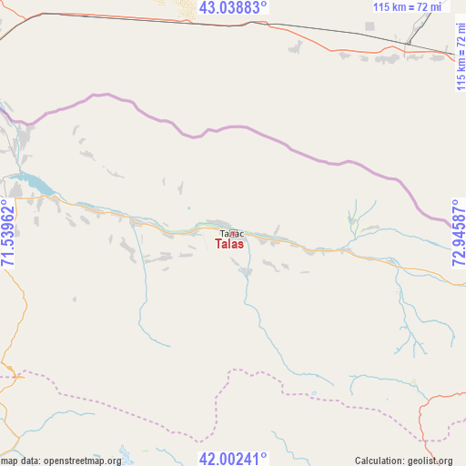
Talas GPS coordinates[2]
42° 31' 21.972" North, 72° 14' 33.864" East
| Map corner | latitude | longitude |
|---|---|---|
| Upper-left | 43.03883°, | 71.53962° |
| Center: | 42.52277°, | 72.24274° |
| Lower-right: | 42.00241°, | 72.94587° |
| Map W x H: | 115.2×115.2 km | = 71.6×71.6mi |
| max Lat: | 42.89106° ⇑20.2% North |
| Talas: | 42.52277° |
| min Lat: | ⇓79.8% South 39.55274° |
| min Long | Talas | max Long |
| 69.3716° | 72.24274° | 78.52702° |
| W 48.8%⇐ | ⇒51.2% E |
Elevation
Elevation of Talas is 1238 m = 4062 ft, and this is 36.6 m = 120 ft above average elevation for this country.
| Max E: |
2638 m = 8655 ft | 39.3% |
| Talas | 1238 m 4062 ft | |
| Avg. | 1201.4 m = 3942 ft | |
Min E: |
504 m = 1654 ft | 60.7% |
See also: Kyrgyzstan elevation on elevation.city.
Geographical zone
Talas is located in North temperate zone (between Tropic of Cancer and the Arctic Circle). Distance of this Northern Tropic circle is 2122.2 km =1318.7 mi to South.| Distance of | km | miles | from Talas |
|---|---|---|---|
| North Pole | 5279 | 3280.2 | to North |
| Arctic Circle | 2673.1 | 1661 | to North |
| Tropic Cancer | 2122.2 | 1318.7 | to South |
| Equator | 4728.1 | 2937.9 | to South |


Nearby cities:
15 places around Talas: (largest is in red/bold)
• Ala-Buka
138.6 km =86.1 mi,  206°
206°
• Bakai-Ata
26.4 km =16.4 mi,  262°
262°
• Belovodskoye
156.3 km =97.1 mi,  77°
77°
• Ivanovo-Alekseyevka
3.8 km =2.4 mi,  314°
314°
• Kaindy
121.9 km =75.7 mi,  74°
74°
• Kanysh-Kyya
126.9 km =78.9 mi,  228°
228°
• Kara-Balta
135.2 km =84 mi, 76°
• Kerben
121.2 km =75.3 mi,  199°
199°
• Kyzyl-Adyr
54.6 km =33.9 mi,  281°
281°
• Pokrovka
57 km =35.4 mi,  294°
294°
• Sosnovka
136 km =84.5 mi, 84°
• Talas
38.8 km =24.1 mi,  118°
118°
• Tash-Kumyr
130.8 km =81.3 mi,  180°
180°
• Toktogul
92.3 km =57.4 mi,  141°
141°
• Üch-Terek
115.7 km =71.9 mi, 136°
Sources, notices
• [Note1] Compared only with cities in Kyrgyzstan existing in our database
• [Src1] Map data: © OpenStreetMap contributors (CC-BY-SA)
• [Src2] Other city data from geonames.org with taken over terms of usage.
• [Src3] Geographical zone / Annual Mean Temperature by Robert A. Rohde @ Wikipedia
