Üch-Terek geodata
Üch-Terek (Jalal-Abad) is a seat of a second-order administrative division; located in Kyrgyzstan in Asia/Bishkek (GMT+6) time zone. In our database, there are 37 cities with bigger population. Compared to other cities in Kyrgyzstan, 63.1% of cities are located further ↓South; 64.3% of cities are located further ←West and 63.1% of cities have higher elevation than Üch-Terek. Note1


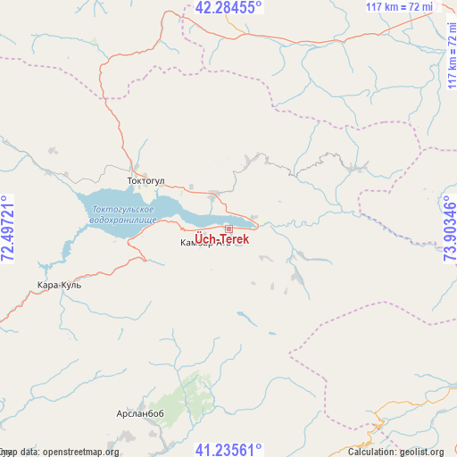
Üch-Terek GPS coordinates[2]
41° 45' 43.992" North, 73° 12' 1.188" East
| Map corner | latitude | longitude |
|---|---|---|
| Upper-left | 42.28455°, | 72.49721° |
| Center: | 41.76222°, | 73.20033° |
| Lower-right: | 41.23561°, | 73.90346° |
| Map W x H: | 116.6×116.6 km | = 72.5×72.5mi |
| max Lat: | 42.89106° ⇑36.9% North |
| Üch-Terek: | 41.76222° |
| min Lat: | ⇓63.1% South 39.55274° |
| min Long | Üch-Terek | max Long |
| 69.3716° | 73.20033° | 78.52702° |
| W 64.3%⇐ | ⇒35.7% E |
Elevation
Elevation of Üch-Terek is 950 m = 3117 ft, and this is 251.4 m = 825 ft below average elevation for this country.
| Max E: |
2638 m = 8655 ft | 63.1% |
| Avg. | 1201.4 m = 3942 ft | |
| Üch-Terek | 950 m = 3117 ft | |
Min E: |
504 m = 1654 ft | 36.9% |
See also: Kyrgyzstan elevation on elevation.city.
Geographical zone
Üch-Terek is located in North temperate zone (between Tropic of Cancer and the Arctic Circle). Distance of this Northern Tropic circle is 2037.6 km =1266.1 mi to South.| Distance of | km | miles | from Üch-Terek |
|---|---|---|---|
| North Pole | 5363.5 | 3332.7 | to North |
| Arctic Circle | 2757.7 | 1713.6 | to North |
| Tropic Cancer | 2037.6 | 1266.1 | to South |
| Equator | 4643.5 | 2885.3 | to South |


Nearby cities:
15 places around Üch-Terek: (largest is in red/bold)
• Bazar-Korgon
89 km =55.3 mi,  205°
205°
• Chayek
110.6 km =68.7 mi,  80°
80°
• Ivanovo-Alekseyevka
119.5 km =74.3 mi,  316°
316°
• Jalal-Abad
93.7 km =58.2 mi,  190°
190°
• Kara Suu
120.9 km =75.1 mi, 193°
• Kazarman
79.5 km =49.4 mi,  120°
120°
• Kochkor-Ata
100.4 km =62.4 mi,  216°
216°
• Massy
91.3 km =56.7 mi, 211°
• Sosnovka
112.9 km =70.2 mi,  30°
30°
• Suzak
99.2 km =61.6 mi, 194°
• Talas
79.7 km =49.5 mi,  325°
325°
• Talas
115.7 km =71.9 mi, 316°
• Tash-Kumyr
94 km =58.4 mi,  240°
240°
• Toktogul
24.8 km =15.4 mi,  300°
300°
• Uzgen
110.6 km =68.7 mi,  175°
175°
Sources, notices
• [Note1] Compared only with cities in Kyrgyzstan existing in our database
• [Src1] Map data: © OpenStreetMap contributors (CC-BY-SA)
• [Src2] Other city data from geonames.org with taken over terms of usage.
• [Src3] Geographical zone / Annual Mean Temperature by Robert A. Rohde @ Wikipedia
