Bishkek geodata
Bishkek is a capital of a political entity; located in Kyrgyzstan in Asia/Bishkek (GMT+6) time zone. With population of 900,000 people, there are 0 cities with bigger population in this country. Compared to other cities in Kyrgyzstan, 96.4% of cities are located further ↓South; 77.4% of cities are located further ←West and 79.8% of cities have higher elevation than Bishkek. Note1


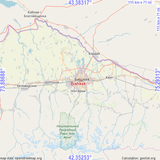
Bishkek GPS coordinates[2]
42° 52' 12" North, 74° 35' 24" East
| Map corner | latitude | longitude |
|---|---|---|
| Upper-left | 43.38317°, | 73.88688° |
| Center: | 42.87°, | 74.59° |
| Lower-right: | 42.35253°, | 75.29313° |
| Map W x H: | 114.6×114.6 km | = 71.2×71.2mi |
| max Lat: | 42.89106° ⇑3.6% North |
| Bishkek: | 42.87° |
| min Lat: | ⇓96.4% South 39.55274° |
| min Long | Bishkek | max Long |
| 69.3716° | 74.59° | 78.52702° |
| W 77.4%⇐ | ⇒22.6% E |
Elevation
Elevation of Bishkek is 767 m = 2516 ft, and this is 434.4 m = 1425 ft below average elevation for this country.
| Max E: |
2638 m = 8655 ft | 79.8% |
| Avg. | 1201.4 m = 3942 ft | |
| Bishkek | 767 m = 2516 ft | |
Min E: |
504 m = 1654 ft | 20.2% |
See also: Bishkek elevation on elevation.city.
Geographical zone
Bishkek is located in North temperate zone (between Tropic of Cancer and the Arctic Circle). Distance of this Northern Tropic circle is 2160.8 km =1342.7 mi to South.| Distance of | km | miles | from Bishkek |
|---|---|---|---|
| North Pole | 5240.4 | 3256.2 | to North |
| Arctic Circle | 2634.5 | 1637 | to North |
| Tropic Cancer | 2160.8 | 1342.7 | to South |
| Equator | 4766.7 | 2961.9 | to South |


Nearby cities:
15 places around Bishkek: (largest is in red/bold)
• Balykchy
138.3 km =85.9 mi,  109°
109°
• Belovodskoye
39.5 km =24.5 mi,  263°
263°
• Chayek
104.9 km =65.2 mi,  183°
183°
• Chuy
56.7 km =35.2 mi,  95°
95°
• Ivanovka
40.4 km =25.1 mi,  87°
87°
• Kaindy
74.7 km =46.4 mi,  266°
266°
• Kant
21.4 km =13.3 mi,  83°
83°
• Kara-Balta
60.8 km =37.8 mi, 264°
• Kemin
90.3 km =56.1 mi, 95°
• Kochkor
120.1 km =74.6 mi,  127°
127°
• Lebedinovka
7.4 km =4.6 mi, 77°
• Sokuluk
23.5 km =14.6 mi, 265°
• Sosnovka
62.3 km =38.7 mi,  245°
245°
• Tokmok
58.1 km =36.1 mi, 93°
• Üch-Terek
168 km =104.4 mi,  222°
222°
In other languages:
- In Spanish: Biskek
- In France: Bichkek
- In German: Bischkek
- In Italian: Biškek
- In Russian: Бишкек
- In Chinese: 比什凯克
Sources, notices
• [Note1] Compared only with cities in Kyrgyzstan existing in our database
• [Src1] Map data: © OpenStreetMap contributors (CC-BY-SA)
• [Src2] Other city data from geonames.org with taken over terms of usage.
• [Src3] Geographical zone / Annual Mean Temperature by Robert A. Rohde @ Wikipedia
