Kant geodata
Kant (Chüy) is a seat of a second-order administrative division; located in Kyrgyzstan in Asia/Bishkek (GMT+6) time zone. With population of 20,181 people, there are 14 cities with bigger population in this country. Compared to other cities in Kyrgyzstan, 100% of cities are located further ↓South; 79.8% of cities are located further ←West and 85.7% of cities have higher elevation than Kant. Note1


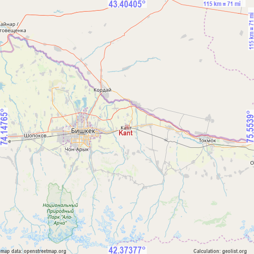
Kant GPS coordinates[2]
42° 53' 27.816" North, 74° 51' 2.772" East
| Map corner | latitude | longitude |
|---|---|---|
| Upper-left | 43.40405°, | 74.14765° |
| Center: | 42.89106°, | 74.85077° |
| Lower-right: | 42.37377°, | 75.5539° |
| Map W x H: | 114.6×114.6 km | = 71.2×71.2mi |
| max Lat: | 42.89106° ⇑0% North |
| Kant: | 42.89106° |
| min Lat: | ⇓100% South 39.55274° |
| min Long | Kant | max Long |
| 69.3716° | 74.85077° | 78.52702° |
| W 79.8%⇐ | ⇒20.2% E |
Elevation
Elevation of Kant is 743 m = 2438 ft, and this is 458.4 m = 1504 ft below average elevation for this country.
| Max E: |
2638 m = 8655 ft | 85.7% |
| Avg. | 1201.4 m = 3942 ft | |
| Kant | 743 m = 2438 ft | |
Min E: |
504 m = 1654 ft | 14.3% |
See also: Kyrgyzstan elevation on elevation.city.
Geographical zone
Kant is located in North temperate zone (between Tropic of Cancer and the Arctic Circle). Distance of this Northern Tropic circle is 2163.1 km =1344.1 mi to South.| Distance of | km | miles | from Kant |
|---|---|---|---|
| North Pole | 5238 | 3254.7 | to North |
| Arctic Circle | 2632.1 | 1635.5 | to North |
| Tropic Cancer | 2163.1 | 1344.1 | to South |
| Equator | 4769 | 2963.3 | to South |


Nearby cities:
15 places around Kant: (largest is in red/bold)
• Balykchy
119.3 km =74.1 mi,  113°
113°
• Belovodskoye
60.9 km =37.8 mi,  263°
263°
• Bishkek
21.4 km =13.3 mi, 263°
• Chayek
110.6 km =68.7 mi,  194°
194°
• Chuy
36.1 km =22.4 mi,  102°
102°
• Ivanovka
19.1 km =11.9 mi,  91°
91°
• Kaindy
96 km =59.7 mi,  265°
265°
• Kara-Balta
82.2 km =51.1 mi, 264°
• Kazarman
178.7 km =111 mi,  202°
202°
• Kemin
69.5 km =43.2 mi, 99°
• Kochkor
105.6 km =65.6 mi,  135°
135°
• Lebedinovka
14.1 km =8.8 mi, 267°
• Sokuluk
44.9 km =27.9 mi, 264°
• Sosnovka
82.9 km =51.5 mi,  250°
250°
• Tokmok
37.1 km =23.1 mi, 98°
Sources, notices
• [Note1] Compared only with cities in Kyrgyzstan existing in our database
• [Src1] Map data: © OpenStreetMap contributors (CC-BY-SA)
• [Src2] Other city data from geonames.org with taken over terms of usage.
• [Src3] Geographical zone / Annual Mean Temperature by Robert A. Rohde @ Wikipedia
