Balykchy geodata
Balykchy (Issyk-Kul) is a populated place; located in Kyrgyzstan in Asia/Bishkek (GMT+6) time zone. With population of 40,000 people, there are 8 cities with bigger population in this country. Compared to other cities in Kyrgyzstan, 75% of cities are located further ↓South; 90.5% of cities are located further ←West and 81% of cities have lower elevation than Balykchy. Note1


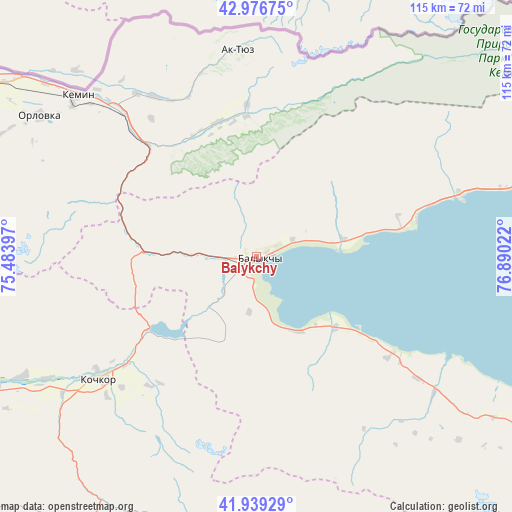
Balykchy GPS coordinates[2]
42° 27' 36.612" North, 76° 11' 13.524" East
| Map corner | latitude | longitude |
|---|---|---|
| Upper-left | 42.97675°, | 75.48397° |
| Center: | 42.46017°, | 76.18709° |
| Lower-right: | 41.93929°, | 76.89022° |
| Map W x H: | 115.4×115.4 km | = 71.7×71.7mi |
| max Lat: | 42.89106° ⇑25% North |
| Balykchy: | 42.46017° |
| min Lat: | ⇓75% South 39.55274° |
| min Long | Balykchy | max Long |
| 69.3716° | 76.18709° | 78.52702° |
| W 90.5%⇐ | ⇒9.5% E |
Elevation
Elevation of Balykchy is 1641 m = 5384 ft, and this is 439.6 m = 1442 ft above average elevation for this country.
| Max E: |
2638 m = 8655 ft | 19% |
| Balykchy | 1641 m 5384 ft | |
| Avg. | 1201.4 m = 3942 ft | |
Min E: |
504 m = 1654 ft | 81% |
See also: Balykchy elevation on elevation.city.
Geographical zone
Balykchy is located in North temperate zone (between Tropic of Cancer and the Arctic Circle). Distance of this Northern Tropic circle is 2115.2 km =1314.3 mi to South.| Distance of | km | miles | from Balykchy |
|---|---|---|---|
| North Pole | 5285.9 | 3284.5 | to North |
| Arctic Circle | 2680 | 1665.3 | to North |
| Tropic Cancer | 2115.2 | 1314.3 | to South |
| Equator | 4721.1 | 2933.6 | to South |


Nearby cities:
15 places around Balykchy: (largest is in red/bold)
• At-Bashi
147 km =91.3 mi,  192°
192°
• Bishkek
138.3 km =85.9 mi,  289°
289°
• Bokombayevskoye
76.5 km =47.5 mi,  119°
119°
• Chayek
149.8 km =93.1 mi,  246°
246°
• Cholpon-Ata
76.3 km =47.4 mi,  73°
73°
• Chuy
84.1 km =52.3 mi,  298°
298°
• Ivanovka
101.9 km =63.3 mi, 297°
• Kadzhi-Say
88.9 km =55.2 mi,  113°
113°
• Kant
119.3 km =74.1 mi, 293°
• Kemin
54.4 km =33.8 mi,  311°
311°
• Kochkor
44.6 km =27.7 mi,  232°
232°
• Lebedinovka
132.1 km =82.1 mi, 290°
• Naryn
115.8 km =72 mi, 188°
• Tokmok
83.9 km =52.1 mi, 300°
• Tossor
108 km =67.1 mi, 107°
In other languages:
- In Spanish: Balikci
- In France: Balyktchy
- In German: Balyktschy
- In Italian: Balykčy
- In Russian: Балыкчи
- In Chinese: 巴雷克奇
Sources, notices
• [Note1] Compared only with cities in Kyrgyzstan existing in our database
• [Src1] Map data: © OpenStreetMap contributors (CC-BY-SA)
• [Src2] Other city data from geonames.org with taken over terms of usage.
• [Src3] Geographical zone / Annual Mean Temperature by Robert A. Rohde @ Wikipedia
